Bank nearby 100% Banco
Coronavirus disease (COVID-19) Situation
confirmed cases
552695
deaths
5856
Venezuela
Bank nearby 100% Banco
100% Banco
Barcelona Wenezuela, Boliwariańskiej Republiki
contacts phone
:
+58
Latitude:
10.143807
, Longitude:
-64.6884948
read more
nearest Bank
116 m
Banco de Venezuela
C.C. Gold Country, Avenida Country Club, Barcelona
Bank
read more
145 m
Banco Exterior
Avenida Country Club, Barcelona
Bank
read more
154 m
Banco Bicentenario
Centro Comercial Gold Country, Carrera 24, Barcelona
Bank
read more
325 m
Banco de Venezuela
Avenida Miranda, Barcelona
Bank
read more
496 m
Bancaribe
Avenida 5 de Julio, Barcelona
Bank
read more
656 m
Banesco Comunitario
20-64 Calle Maturin, Barcelona
Bank
read more
673 m
Banesco
Avenida Fuerzas Armadas, Barcelona
Bank
read more
677 m
BANESCO, C. C, Neverí Plaza
Avenida Fuerzas Armadas, Barcelona
Bank
read more
681 m
Banco Del Sur
Barcelona
Bank
read more
681 m
Banco Fondo Comun
Barcelona
Bank
read more
682 m
Banco de Venezuela
Calle Santander, Barcelona
Bank
read more
688 m
Banco Provincial Neveri Plaza
Avenida Fuerzas Armadas, Barcelona
Bank
read more
712 m
BBVA
Barcelona
Bank
read more
712 m
BBVA Provincial
Barcelona
Bank
read more
765 m
Banco Mercantil
Frente a la Plaza Bolívar, Calle Maturin, Barcelona
Bank
read more
765 m
Banco Mercantil Of. Barcelona
Frente a la Plaza Bolívar, Calle Maturin, Barcelona
Bank
read more
803 m
Banco Plaza
Barcelona
Bank
read more
848 m
B.O.D. Banco Occidental de Descuento
Calle Eulalia Buroz, Barcelona
Bank
read more
1.096 km
Banco de Venezuela
Calle Bolivar, Barcelona
Bank
read more
1.361 km
Banesco
Boulevard 5 de Julio, Barcelona
Bank
read more
3.342 km
BANAVIH
Barcelona
Bank
read more
3.716 km
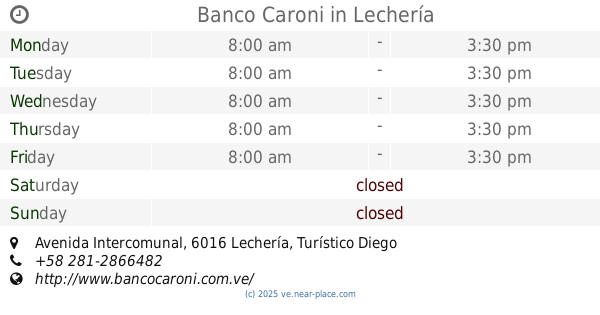
Banco Caroni
C.C. Vista Mar, PB. Edo., Avenida Intercomunal, Lechería
Bank
read more
4.504 km
Banco Occidental de Descuento (BOD)
Avenida Jorge Rodríguez, Lechería
Bank
read more
4.652 km
BFC Banco Fondo Común
Lecheria
Bank
read more
4.652 km
Banco Fondo Común
Lechería
Bank
read more
📑
all categories
Accounting
Administrative area level 1
Administrative area level 2
Airport
Amusement park
Aquarium
Art gallery
Atm
Bakery
Bank
Bar
Beauty salon
Bicycle store
Book store
Bowling alley
Bus station
Cafe
Campground
Car dealer
Car rental
Car repair
Car wash
Casino
Cemetery
Church
City hall
Clothing store
Colloquial area
Convenience store
Courthouse
Dentist
Department store
Doctor
Electrician
Electronics store
Embassy
Finance
Fire station
Florist
Food
Funeral home
Furniture store
Gas station
General contractor
Grocery or supermarket
Gym
Hair care
Hardware store
Health
Hindu Temple
Home goods store
Hospital
Insurance agency
Jewelry store
Laundry
Lawyer
Library
Light rail station
Liquor store
Local government office
Locality
Locksmith
Lodging
Meal delivery
Meal takeaway
Mosque
Movie rental
Movie theater
Moving company
Museum
Natural feature
Neighborhood
Night club
Painter
Park
Parking
Pet store
Pharmacy
Physiotherapist
Place of worship
Plumber
Point of interest
Police
Post office
Premise
Real estate agency
Restaurant
Roofing contractor
Route
Rv park, camping
School
Shoe store
Shopping mall
Spa
Stadium
Storage
Store
Subpremise
Subway station
Supermarket
Synagogue
Taxi stand
Train station
Transit station
Travel agency
University
Veterinary care
Zoo
administrative area level 3
sublocality level 1
↑