Bar nearby Bropatia
Venezuela
Bar nearby Bropatia
Bropatia
Calle Colombia, Caracas Venezuela, República Bolivariana de
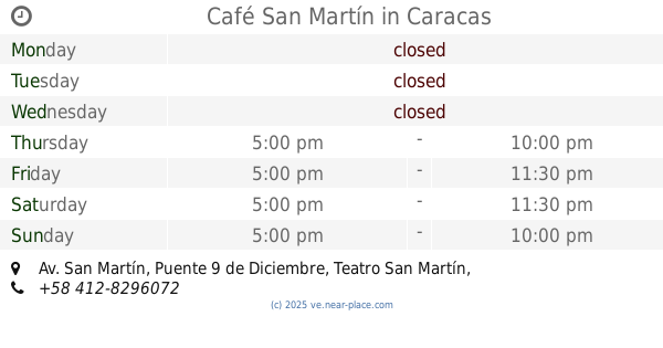
contacts phone
:
+58
Latitude:
10.5156324
, Longitude:
-66.9455496
read more
nearest Bar
135 m
Bar El Torero
Calle Maury, Caracas
Bar
read more
391 m
Betcris Catia
Caracas
Bar
read more
461 m
Bar Rest. 22 De Mayo
Caracas
Bar
read more
638 m
Producciones ZENZEY
Caracas
Bar
read more
978 m
Bar y Expendio de Licores
24 Calle Brasil, Caracas
Bar
read more
1.565 km
Bodega Palacios C.A
Caracas
Bar
read more
1.728 km
Fuente De Soda La Golondrina
Caracas
Bar
read more
1.797 km
Prolicor Mariperez
Caracas
Bar
read more
1.834 km
Licorería Los Morochos
Caracas
Bar
read more
1.908 km
Licoreria EL MORANERO
Avenida Morán, Caracas
Bar
read more
2.363 km
Bar Restaurant San Martin Grill "La Tasquita"
Caracas
Bar
read more
2.464 km
Antiguo bar boyaca
Caracas
Bar
read more
2.629 km
Bar La Estación El Gardeliano
Caracas
Bar
read more
2.82 km
Café San Martín
Av. San Martín, Puente 9 de Diciembre, Teatro San Martín, Salida Metro, Artigas, Caracas
Bar
read more
2.925 km
La Gallera del Silencio
Caracas
Bar
read more
3.167 km
Casa De Paulo
Avenida Sur 12, Caracas
Bar
read more
3.446 km
Club Canarios
Avenida Principal El Paraíso, Caracas
Bar
read more
3.453 km
Ciudad Colonia
Avenida José Antonio Páez, Caracas
Bar
read more
3.51 km
Ibanez producciones
Avenida Oeste 16, Caracas
Bar
read more
4.126 km
Pollos Carral
Avenida Este 11, Caracas
Bar
read more
4.13 km
El Mesón de San José
Caracas
Bar
read more
4.234 km
Licoreria Carupaneros
Caracas
Bar
read more
5.194 km
Sanguchito Bar
Edificio, Avenida Sur 21, Caracas
Bar
read more
5.29 km
Restaurante El Limón
Avenida Lecuna, Caracas
Bar
read more
5.359 km
Licorería Cacique
Caracas
Bar
read more
📑
all categories
Accounting
Administrative area level 1
Administrative area level 2
Airport
Amusement park
Aquarium
Art gallery
Atm
Bakery
Bank
Bar
Beauty salon
Bicycle store
Book store
Bowling alley
Bus station
Cafe
Campground
Car dealer
Car rental
Car repair
Car wash
Casino
Cemetery
Church
City hall
Clothing store
Colloquial area
Convenience store
Courthouse
Dentist
Department store
Doctor
Electrician
Electronics store
Embassy
Finance
Fire station
Florist
Food
Funeral home
Furniture store
Gas station
General contractor
Grocery or supermarket
Gym
Hair care
Hardware store
Health
Hindu Temple
Home goods store
Hospital
Insurance agency
Jewelry store
Laundry
Lawyer
Library
Light rail station
Liquor store
Local government office
Locality
Locksmith
Lodging
Meal delivery
Meal takeaway
Mosque
Movie rental
Movie theater
Moving company
Museum
Natural feature
Neighborhood
Night club
Painter
Park
Parking
Pet store
Pharmacy
Physiotherapist
Place of worship
Plumber
Point of interest
Police
Post office
Premise
Real estate agency
Restaurant
Roofing contractor
Route
Rv park, camping
School
Shoe store
Shopping mall
Spa
Stadium
Storage
Store
Subpremise
Subway station
Supermarket
Synagogue
Taxi stand
Train station
Transit station
Travel agency
University
Veterinary care
Zoo
administrative area level 3
sublocality level 1
↑