Cafe nearby La Patilla Express
Coronavirus disease (COVID-19) Situation
confirmed cases
552695
deaths
5856
Venezuela
Cafe nearby La Patilla Express
La Patilla Express
San Cristobal Venezuela, Bolivarische Republik
contacts phone
:
+58
Latitude:
7.765058
, Longitude:
-72.2290611
read more
nearest Cafe
301 m
Pasapalos Tequegochos
San Cristobal
Cafe
read more
639 m
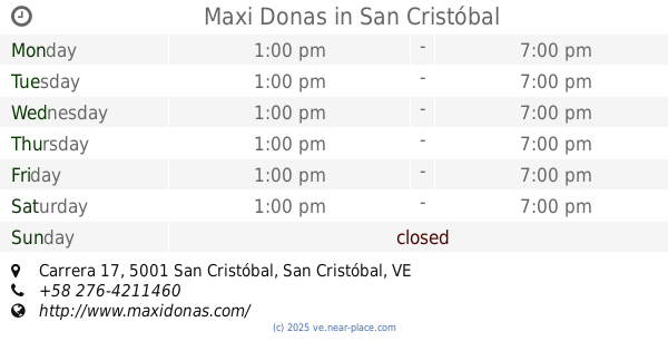
Maxi Donas
Diagonal al Iufront, Carrera 17, San Cristóbal
Cafe
read more
661 m
La Tinaja Andina
San Cristóbal
Cafe
read more
702 m
cafetin la estacion
Carrera 10,San Cristóbal 5001
Cafe
read more
752 m
Panaderia Concordia Express III C.A.
San Cristóbal
Cafe
read more
769 m
MagnoliaCafe
San Cristóbal
Cafe
read more
775 m
Autolavado Mister Clean
Calle 11, San Cristóbal
Cafe
read more
818 m
Cafeteria Brostisamy
San Cristobal
Cafe
read more
831 m
Dulces Cupcakes
Carrera 13 entre calles 12 y 13 local #12-60, San Cristóbal
Cafe
read more
850 m
Kfe Pasteles Y Empanadas
San Cristóbal
Cafe
read more
879 m
Esquina Del Amor
Avenida 8va, San Cristóbal
Cafe
read more
903 m
Cafe Todo Futbol
Carrera 10, San Cristóbal
Cafe
read more
937 m
Pa-Kua Feng Shui Green Market Cafe
Pasaje Acueducto, San Cristóbal
Cafe
read more
941 m
Paraiso Café
San Carlos, San Cristóbal, 5001
Cafe
read more
943 m
Cafeteria y Panaderia Capacho Express
Calle 9, San Cristóbal
Cafe
read more
953 m
Im Reposteria
entre y, Calle 14
Cafe
read more
966 m
Cafeteria Chia Sua
San Cristobal
Cafe
read more
984 m
Mundo Equilibrio
Calle 14, San Cristóbal
Cafe
read more
987 m
FRUTOScafé
Centro Comercial El Pinar PB. Minitienda 01
Cafe
read more
1.023 km
Mundoequilibriosc
Calle 14, San Cristóbal
Cafe
read more
1.041 km
Pastelven
San Cristobal
Cafe
read more
1.069 km
Machiatto Cafe La Mérida
San Cristobal
Cafe
read more
1.116 km
DeYú Café
San Cristóbal
Cafe
read more
1.169 km
Maxi Donas Tachira I
Carrera 20, San Cristóbal
Cafe
read more
1.341 km
El Imperio De Los Desayunos
entre y, Carrera 20, San Cristóbal
Cafe
read more
📑
all categories
Accounting
Administrative area level 1
Administrative area level 2
Airport
Amusement park
Aquarium
Art gallery
Atm
Bakery
Bank
Bar
Beauty salon
Bicycle store
Book store
Bowling alley
Bus station
Cafe
Campground
Car dealer
Car rental
Car repair
Car wash
Casino
Cemetery
Church
City hall
Clothing store
Colloquial area
Convenience store
Courthouse
Dentist
Department store
Doctor
Electrician
Electronics store
Embassy
Finance
Fire station
Florist
Food
Funeral home
Furniture store
Gas station
General contractor
Grocery or supermarket
Gym
Hair care
Hardware store
Health
Hindu Temple
Home goods store
Hospital
Insurance agency
Jewelry store
Laundry
Lawyer
Library
Light rail station
Liquor store
Local government office
Locality
Locksmith
Lodging
Meal delivery
Meal takeaway
Mosque
Movie rental
Movie theater
Moving company
Museum
Natural feature
Neighborhood
Night club
Painter
Park
Parking
Pet store
Pharmacy
Physiotherapist
Place of worship
Plumber
Point of interest
Police
Post office
Premise
Real estate agency
Restaurant
Roofing contractor
Route
Rv park, camping
School
Shoe store
Shopping mall
Spa
Stadium
Storage
Store
Subpremise
Subway station
Supermarket
Synagogue
Taxi stand
Train station
Transit station
Travel agency
University
Veterinary care
Zoo
administrative area level 3
sublocality level 1
↑