Cafe nearby Macchiatocafe
Venezuela
Cafe nearby Macchiatocafe
Macchiatocafe
San Cristobal Venezuela, Bolivarian Republic of
contacts phone
:
+58
Latitude:
7.7706149
, Longitude:
-72.2164651
read more
nearest Cafe
16 m
Macchiatto cafe
con, Calle 12, San Cristóbal
Cafe
read more
154 m
CopiasCafé San Cristobal
Calle 12, San Cristóbal
Cafe
read more
236 m
Cielito Tinto
San Cristobal
Cafe
read more
249 m
Sttugar caffe
San Cristobal
Cafe
read more
261 m
Cheesecake Express
Pasaje Acueducto, San Cristóbal
Cafe
read more
283 m
La Casa Del Árbol Café
San Cristobal
Cafe
read more
327 m
Watusi Cafe
San Cristobal
Cafe
read more
337 m
Watusi Fast Food mini Market
San Cristobal
Cafe
read more
344 m
Galos Cafe C.A.
centro comercial milenia plaza, Calle 10, San Cristóbal
Cafe
read more
450 m
HIBRIDOS CAFE
ENTRE Y 21, Carrera 20, San Cristóbal
Cafe
read more
459 m
Galería Café Dalí
Calle 15, San Cristóbal
Cafe
read more
510 m
Pastelven
San Cristobal
Cafe
read more
510 m
El Imperio De Los Desayunos
entre y, Carrera 20, San Cristóbal
Cafe
read more
545 m
BEAÜ Shop And Coffee
San Cristobal
Cafe
read more
572 m
Beaufashion
San Cristóbal
Cafe
read more
596 m
Pa-Kua Feng Shui Green Market Cafe
Pasaje Acueducto, San Cristóbal
Cafe
read more
867 m
La Tinaja Andina
San Cristóbal
Cafe
read more
881 m
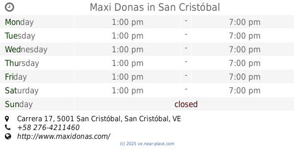
Maxi Donas
Diagonal al Iufront, Carrera 17, San Cristóbal
Cafe
read more
910 m
Paraiso Café
San Carlos, San Cristóbal, 5001
Cafe
read more
913 m
Empanadas y pasteles
San Cristobal
Cafe
read more
915 m
Autolavado Mister Clean
Calle 11, San Cristóbal
Cafe
read more
929 m
Mundoequilibriosc
Calle 14, San Cristóbal
Cafe
read more
976 m
Pan La Grita
Carrera 16 entre calle 15 y 16
Cafe
read more
1.03 km
Panaderia Y Pasteleria Mi Pan Andino
Avenida 19 de Abril, San Cristóbal
Cafe
read more
1.044 km
Panaderia Su Pan Andino
Avenida 19 de Abril, San Cristóbal
Cafe
read more
📑
all categories
Accounting
Administrative area level 1
Administrative area level 2
Airport
Amusement park
Aquarium
Art gallery
Atm
Bakery
Bank
Bar
Beauty salon
Bicycle store
Book store
Bowling alley
Bus station
Cafe
Campground
Car dealer
Car rental
Car repair
Car wash
Casino
Cemetery
Church
City hall
Clothing store
Colloquial area
Convenience store
Courthouse
Dentist
Department store
Doctor
Electrician
Electronics store
Embassy
Finance
Fire station
Florist
Food
Funeral home
Furniture store
Gas station
General contractor
Grocery or supermarket
Gym
Hair care
Hardware store
Health
Hindu Temple
Home goods store
Hospital
Insurance agency
Jewelry store
Laundry
Lawyer
Library
Light rail station
Liquor store
Local government office
Locality
Locksmith
Lodging
Meal delivery
Meal takeaway
Mosque
Movie rental
Movie theater
Moving company
Museum
Natural feature
Neighborhood
Night club
Painter
Park
Parking
Pet store
Pharmacy
Physiotherapist
Place of worship
Plumber
Point of interest
Police
Post office
Premise
Real estate agency
Restaurant
Roofing contractor
Route
Rv park, camping
School
Shoe store
Shopping mall
Spa
Stadium
Storage
Store
Subpremise
Subway station
Supermarket
Synagogue
Taxi stand
Train station
Transit station
Travel agency
University
Veterinary care
Zoo
administrative area level 3
sublocality level 1
↑