Food nearby Bodega Vieja
Coronavirus disease (COVID-19) Situation
confirmed cases
552695
deaths
5856
Venezuela
Food nearby Bodega Vieja
Bodega Vieja
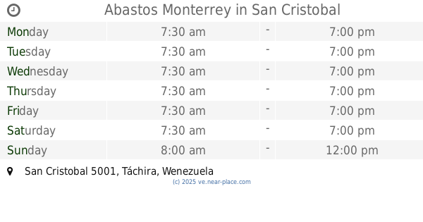
San Cristóbal 5001, Táchira, Venezuela
contacts phone
:
+58
Latitude:
7.7750352
, Longitude:
-72.2275315
larger map & directions
read more
nearest Food
40 m
Cafetin Los Picapiedras
San Carlos, San Cristóbal 5001
Food
read more
428 m
Bodega Brisas del Torbes
San Cristobal
Food
read more
516 m
Pan Andes
San Cristóbal
Food
read more
631 m
Abastos El Manguito.
Carrera 15, San Cristóbal
Food
read more
721 m
Festejos La Unica
San Cristobal
Food
read more
818 m
Distribuidora El Olam CA
Barrio Obrero Sector San Carlos Cra. 14 entre calles 9 y 10, San Cristóbal
Food
read more
822 m
Festejos Infantiles Risitas
Carrera 14, San Cristóbal
Food
read more
852 m
Residencias Paraiso Suite
San Cristobal
Food
read more
890 m
Super pollos SRL
11-6 Carrera 18, San Cristóbal
Food
read more
941 m
Bodega Carmen Rey
calle16 con carrera 19 N 19-2
Food
read more
976 m
Abastos Monterrey
San Cristobal
Food
read more
1.039 km
Ella Cioccolatos
Calle 2, San Cristóbal
Food
read more
1.046 km
Ella CioCcolatos
San Cristóbal
Food
read more
1.432 km
Berdes Restaurant
Pasaje Acueducto, San Cristóbal
Food
read more
1.454 km
Bodega El Ché
San Cristobal
Food
read more
1.628 km
agropecuaria Castro Mendez, C.A.
San Cristobal
Food
read more
1.724 km
Víveres Y Frutería Rondón
San Cristóbal
Food
read more
1.888 km
TIMOR DEI VANEGAS
Avenida Madre Juana, San Cristóbal
Food
read more
2.09 km
Distribuciones Principal C.A.
San Cristobal
Food
read more
2.111 km
ACOMER
San Cristóbal
Food
read more
2.147 km
Agencia de Festejos Isabelita
San Cristobal
Food
read more
2.16 km
Pandock del Tachira
San Cristobal
Food
read more
2.294 km
Restaurant y Fuente de Soda La Arepa Cuadrada S.R.L
Calle 6, San Cristóbal
Food
read more
2.585 km
Festejos con Stylos
San Cristóbal
Food
read more
2.705 km
D'Bernar
Avenida principal de Pueblo Nievo # Z-273, San Cristóbal
Food
read more
📑
all categories
Accounting
Administrative area level 1
Administrative area level 2
Airport
Amusement park
Aquarium
Art gallery
Atm
Bakery
Bank
Bar
Beauty salon
Bicycle store
Book store
Bowling alley
Bus station
Cafe
Campground
Car dealer
Car rental
Car repair
Car wash
Casino
Cemetery
Church
City hall
Clothing store
Colloquial area
Convenience store
Courthouse
Dentist
Department store
Doctor
Electrician
Electronics store
Embassy
Finance
Fire station
Florist
Food
Funeral home
Furniture store
Gas station
General contractor
Grocery or supermarket
Gym
Hair care
Hardware store
Health
Hindu Temple
Home goods store
Hospital
Insurance agency
Jewelry store
Laundry
Lawyer
Library
Light rail station
Liquor store
Local government office
Locality
Locksmith
Lodging
Meal delivery
Meal takeaway
Mosque
Movie rental
Movie theater
Moving company
Museum
Natural feature
Neighborhood
Night club
Painter
Park
Parking
Pet store
Pharmacy
Physiotherapist
Place of worship
Plumber
Point of interest
Police
Post office
Premise
Real estate agency
Restaurant
Roofing contractor
Route
Rv park, camping
School
Shoe store
Shopping mall
Spa
Stadium
Storage
Store
Subpremise
Subway station
Supermarket
Synagogue
Taxi stand
Train station
Transit station
Travel agency
University
Veterinary care
Zoo
administrative area level 3
sublocality level 1
↑