Gym nearby Fit Place
Coronavirus disease (COVID-19) Situation
confirmed cases
552695
deaths
5856
Venezuela
Gym nearby Fit Place
Fit Place
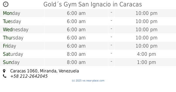
Caracas 1064, Distrito Capital, Venezuela
contacts phone
:
+58
Latitude:
10.4856956
, Longitude:
-66.8550811
larger map & directions
read more
nearest Gym
119 m
Nautilus Fitness Center
Caracas
Gym
read more
294 m
ACADEMIA SLAM
Calle Los Ángeles, Caracas
Gym
read more
655 m
Image Gym
Caracas
Gym
read more
779 m
Maha Choan
Avenida Francisco de Miranda, Caracas
Gym
read more
832 m
Sweat Gym
Avenida Guaicaipuro, Caracas
Gym
read more
858 m
Retraining
Avenida Principal de las Mercedes, Caracas
Gym
read more
944 m
Padma Yoga
Nivel Trasnocho, Avenue Principal las Mercedes, Caracas
Gym
read more
965 m
Valle Fit Center Bello Campo
Caracas
Gym
read more
987 m
Gimnasio 398
Edificio Centro 398 Calle California, Caracas
Gym
read more
1.031 km
MEDKAR CC Lido
CC Lido, Niv Parque, El, Caracas
Gym
read more
1.031 km
MEDKAR, Medicina Deportiva, Rehabilitación, Gym & Spa
CC Lido, Niv Parque, El, Caracas
Gym
read more
1.05 km
Tapah Yoga
Caracas
Gym
read more
1.324 km
Gold´s Gym San Ignacio
Caracas
Gym
read more
1.421 km
estadio ''C.E. Fray Luis 1'' las mercedes
urb complejo deportivo la guacamaya, Calle La Cinta, Caracas
Gym
read more
1.543 km
TaoMMA
Caracas
Gym
read more
1.556 km
Gym
Caracas
Gym
read more
1.585 km
Fitpointve
Caracas
Gym
read more
1.648 km
Complejo Deportivo El Bosque
Caracas
Gym
read more
1.657 km
Atlantes TC
Caracas
Gym
read more
1.971 km
Yoga Pedregal
Caracas
Gym
read more
2.077 km
Zonas MTS
Caracas
Gym
read more
2.184 km
Jenel Sport
Calle El Mirador, Caracas
Gym
read more
2.192 km
Jenel Studio Pole Sport Dance & Fitness
Calle El Mirador, Caracas
Gym
read more
2.192 km
Club Jenel Sport / Pole Dance & Fitness
Calle El Mirador, Caracas
Gym
read more
2.375 km
San Luis Fitness Center
Calle Comercio, Caracas
Gym
read more
📑
all categories
Accounting
Administrative area level 1
Administrative area level 2
Airport
Amusement park
Aquarium
Art gallery
Atm
Bakery
Bank
Bar
Beauty salon
Bicycle store
Book store
Bowling alley
Bus station
Cafe
Campground
Car dealer
Car rental
Car repair
Car wash
Casino
Cemetery
Church
City hall
Clothing store
Colloquial area
Convenience store
Courthouse
Dentist
Department store
Doctor
Electrician
Electronics store
Embassy
Finance
Fire station
Florist
Food
Funeral home
Furniture store
Gas station
General contractor
Grocery or supermarket
Gym
Hair care
Hardware store
Health
Hindu Temple
Home goods store
Hospital
Insurance agency
Jewelry store
Laundry
Lawyer
Library
Light rail station
Liquor store
Local government office
Locality
Locksmith
Lodging
Meal delivery
Meal takeaway
Mosque
Movie rental
Movie theater
Moving company
Museum
Natural feature
Neighborhood
Night club
Painter
Park
Parking
Pet store
Pharmacy
Physiotherapist
Place of worship
Plumber
Point of interest
Police
Post office
Premise
Real estate agency
Restaurant
Roofing contractor
Route
Rv park, camping
School
Shoe store
Shopping mall
Spa
Stadium
Storage
Store
Subpremise
Subway station
Supermarket
Synagogue
Taxi stand
Train station
Transit station
Travel agency
University
Veterinary care
Zoo
administrative area level 3
sublocality level 1
↑