Local government office nearby Distrito Sanitario #4
Coronavirus disease (COVID-19) Situation
confirmed cases
552695
deaths
5856
Venezuela
Local government office nearby Distrito Sanitario #4
Distrito Sanitario #4
Calle Real Jardines Del Valle, 1090, Caracas, Libertador, VE Venezuela
contacts phone
:
+58
Latitude:
10.4597472
, Longitude:
-66.913638
larger map & directions
read more
nearest Local government office
657 m
UBCH JARDIN DE INFANCIA PEDRO PEREZ DELGADO
Calle 14, Caracas
Local government office
read more
1.435 km
Parish Civil Registration Unit El Valle
Caracas
Local government office
read more
1.435 km
Unidad Parroquial de Registro Civil El Valle
Caracas
Local government office
read more
1.736 km
SAIME Coche
C.C. Coche, Piso 3, a la salida de la Est. del Metro Coche, Avenida Intercomunal del Valle, Caracas
Local government office
read more
1.918 km
Registro Civil de Santa Rosalía
Avenida Ayacucho, Caracas
Local government office
read more
2.297 km
Urbanismo Ciudad tiuna
Caracas
Local government office
read more
2.564 km
Registro Civil El Paraiso
Distrito Capital
Local government office
read more
2.564 km
Registro Civil El Paraiso
Capital District
Local government office
read more
2.567 km
San Pedro Prefecture
Calle Los Malabares, Caracas
Local government office
read more
2.567 km
Prefectura san pedro
Calle Los Malabares, Caracas
Local government office
read more
2.585 km
santa rosalia 警务站
Caracas
Local government office
read more
2.77 km
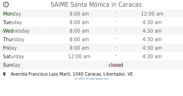
SAIME Santa Mónica
Edif. Centauro, Avenida Francisco Lazo Martí, Caracas
Local government office
read more
3.448 km
SUNAHIP (Superintendencia Nacional de Actividades Hípicas)
Caracas
Local government office
read more
3.528 km
Policia de Caracas
10°28'36.5"N 66°56'27., Avenida Este 0, Caracas
Local government office
read more
3.852 km
Instituto de Oncologia y Hematologia
Caracas
Local government office
read more
4.025 km
Registro Civil San Agustín
Caracas
Local government office
read more
4.519 km
Secretaria de Salud
Avenida Washington, Caracas
Local government office
read more
4.828 km
MPPS
Avenida Bolívar, Caracas
Local government office
read more
4.902 km
el regalo universal, c.a.
Avenida Las Acacias, Caracas
Local government office
read more
4.929 km
oficina regional cne
Paseo Colón, Caracas
Local government office
read more
4.985 km
Consejo Comunal El Araguaney 83
Sector El Araguaney, Caracas
Local government office
read more
5.241 km
Consejo Federal de Gobierno
Caracas
Local government office
read more
5.65 km
La empajada de siria
Caracas
Local government office
read more
5.721 km
Juuzgado 25 del Municipio
Edificio Tepuy, Avenida Francisco Solano Lopez, Caracas
Local government office
read more
6.493 km
SAIME
Avenida Simón Bolívar, Caracas
Local government office
read more
📑
all categories
Accounting
Administrative area level 1
Administrative area level 2
Airport
Amusement park
Aquarium
Art gallery
Atm
Bakery
Bank
Bar
Beauty salon
Bicycle store
Book store
Bowling alley
Bus station
Cafe
Campground
Car dealer
Car rental
Car repair
Car wash
Casino
Cemetery
Church
City hall
Clothing store
Colloquial area
Convenience store
Courthouse
Dentist
Department store
Doctor
Electrician
Electronics store
Embassy
Finance
Fire station
Florist
Food
Funeral home
Furniture store
Gas station
General contractor
Grocery or supermarket
Gym
Hair care
Hardware store
Health
Hindu Temple
Home goods store
Hospital
Insurance agency
Jewelry store
Laundry
Lawyer
Library
Light rail station
Liquor store
Local government office
Locality
Locksmith
Lodging
Meal delivery
Meal takeaway
Mosque
Movie rental
Movie theater
Moving company
Museum
Natural feature
Neighborhood
Night club
Painter
Park
Parking
Pet store
Pharmacy
Physiotherapist
Place of worship
Plumber
Point of interest
Police
Post office
Premise
Real estate agency
Restaurant
Roofing contractor
Route
Rv park, camping
School
Shoe store
Shopping mall
Spa
Stadium
Storage
Store
Subpremise
Subway station
Supermarket
Synagogue
Taxi stand
Train station
Transit station
Travel agency
University
Veterinary care
Zoo
administrative area level 3
sublocality level 1
↑