Restaurant nearby Chaps Fast Food
Coronavirus disease (COVID-19) Situation
confirmed cases
552695
deaths
5856
Venezuela
Restaurant nearby Chaps Fast Food
Chaps Fast Food
Coro Wenezuela, Boliwariańskiej Republiki
contacts phone
:
+58
Latitude:
11.4109836
, Longitude:
-69.6690877
read more
nearest Restaurant
253 m
Sr.zapata Restaurate
Calle Falcón, Coro
Restaurant
read more
332 m
Mega Hamburguesas C.A.
Calle Falcón, Coro
Restaurant
read more
397 m
Sr Zapata Grill & Fried
Calle Buchivacoa, Coro
Restaurant
read more
437 m
Modena Pizza
Coro
Restaurant
read more
455 m
Players Sports Bar
Coro
Restaurant
read more
494 m
despacho
Coro
Restaurant
read more
514 m
Beirut Cafe & Grill
Coro
Restaurant
read more
524 m
Pollos y Alimentos Gerald's
Avenida Independencia, Coro
Restaurant
read more
535 m
Olé Olé Plaza Pizza & Grill
Avenida Independencia, Coro
Restaurant
read more
550 m
Las 3 Anas
Calle Jose David Curiel, Coro
Restaurant
read more
592 m
Subway
Avenida Independencia, Coro
Restaurant
read more
593 m
Teo's Burger
Calle González, Coro
Restaurant
read more
627 m
Bacoa Café
Casa de las ventanas de hierro., Calle Urdaneta, Coro
Restaurant
read more
636 m
El Jampi del Sabor
Callejon Jurado, Coro
Restaurant
read more
708 m
Cafe El Caquetio CA
Avenida Manaure, Coro
Restaurant
read more
741 m
Hispanos Grill
Coro
Restaurant
read more
746 m
Luncheria El Vagon
Coro
Restaurant
read more
817 m
El Porton De Arturo
Avenida Roosvelt, Coro
Restaurant
read more
838 m
El Gaitero Club
Avenida Los Medanos, Coro
Restaurant
read more
859 m
Burger King
Avenida Independencia, Coro
Restaurant
read more
866 m
Restaurant Gengibre y Albahacas
Avenida Josefa Camejo, Coro
Restaurant
read more
940 m
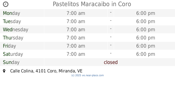
Pastelitos Maracaibo
Avenida Romulo Gallego, Calle Colina, Coro
Restaurant
read more
963 m
Capri Burger
Coro
Restaurant
read more
966 m
Morlop Resto Bar
Coro
Restaurant
read more
989 m
Grapos Pollo
Coro
Restaurant
read more
📑
all categories
Accounting
Administrative area level 1
Administrative area level 2
Airport
Amusement park
Aquarium
Art gallery
Atm
Bakery
Bank
Bar
Beauty salon
Bicycle store
Book store
Bowling alley
Bus station
Cafe
Campground
Car dealer
Car rental
Car repair
Car wash
Casino
Cemetery
Church
City hall
Clothing store
Colloquial area
Convenience store
Courthouse
Dentist
Department store
Doctor
Electrician
Electronics store
Embassy
Finance
Fire station
Florist
Food
Funeral home
Furniture store
Gas station
General contractor
Grocery or supermarket
Gym
Hair care
Hardware store
Health
Hindu Temple
Home goods store
Hospital
Insurance agency
Jewelry store
Laundry
Lawyer
Library
Light rail station
Liquor store
Local government office
Locality
Locksmith
Lodging
Meal delivery
Meal takeaway
Mosque
Movie rental
Movie theater
Moving company
Museum
Natural feature
Neighborhood
Night club
Painter
Park
Parking
Pet store
Pharmacy
Physiotherapist
Place of worship
Plumber
Point of interest
Police
Post office
Premise
Real estate agency
Restaurant
Roofing contractor
Route
Rv park, camping
School
Shoe store
Shopping mall
Spa
Stadium
Storage
Store
Subpremise
Subway station
Supermarket
Synagogue
Taxi stand
Train station
Transit station
Travel agency
University
Veterinary care
Zoo
administrative area level 3
sublocality level 1
↑