School nearby Escuela San Bosco
Coronavirus disease (COVID-19) Situation
confirmed cases
552695
deaths
5856
Venezuela
School nearby Escuela San Bosco
Escuela San Bosco
Caracas Wenezuela, Boliwariańskiej Republiki
contacts phone
:
+58
Latitude:
10.4931384
, Longitude:
-66.9082521
read more
nearest School
351 m
Colegio Corazón De María
Avenida Este 14, Caracas
School
read more
384 m
Escuela del Sebin, Helicoide de Caracas.
Caracas
School
read more
463 m
Colegio Fe y Alegría Don Pedro
Caracas
School
read more
504 m
Corazón de María
Avenida Este 14, Caracas
School
read more
525 m
Colegio Fray Luis de León
Avenida Fuerzas Armadas, Caracas
School
read more
655 m
U.E. Colegio Santa Cecilia
Avenida Sur 5, Caracas
School
read more
732 m
Liceo Independencia
Avenida Este 12, Caracas
School
read more
749 m
U. E. Luis Razetti
Caracas
School
read more
772 m
Colegio Pablo VI
Caracas
School
read more
779 m
Guarderia Divina pastora (Asamblea Nacional)
Nte,, Caracas
School
read more
788 m
U.E. Paulo VI
Caracas
School
read more
798 m
Colegio Padre Machado Fe y Alegría
Caracas
School
read more
889 m
Unidad Educativa Colegio Nuestra Madre
Calle Nicaragua, Quinta Rayo, Avenida Nicaragua, Caracas
School
read more
916 m
Centro De Formación Coral Inocente Carreño
Caracas
School
read more
964 m
Unidad Educativa Los Mayas
Santa Teresa
School
read more
964 m
Unidad Educativa Los Mayas
Santa Teresa del Tuy
School
read more
979 m
CENDA Las Acacias
Caracas
School
read more
1.029 km
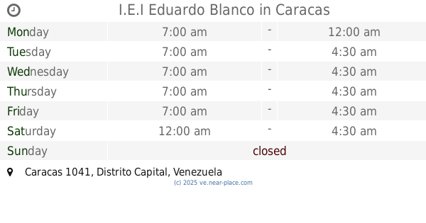
I.E.I Eduardo Blanco
Caracas
School
read more
1.031 km
Liceo Andrés Bello
La Candelaria
School
read more
1.04 km
U.E.N Teresa Carreño
Avenida Sur 2, Caracas
School
read more
1.072 km
P.A. EULALIA BUROZ
Calle 2, Caracas
School
read more
1.135 km
Unidad Educativa Parroquial de Santa Teresa
Caracas
School
read more
1.219 km
Colegio Las Acacias
Avenida El Parque, Caracas
School
read more
1.287 km
Unidad Educativa Privada Fundamérica
Avenida Lecuna, Caracas
School
read more
1.301 km
UED RITA FREIRE DE GALLEGOS
Avenida Sur 4
School
read more
📑
all categories
Accounting
Administrative area level 1
Administrative area level 2
Airport
Amusement park
Aquarium
Art gallery
Atm
Bakery
Bank
Bar
Beauty salon
Bicycle store
Book store
Bowling alley
Bus station
Cafe
Campground
Car dealer
Car rental
Car repair
Car wash
Casino
Cemetery
Church
City hall
Clothing store
Colloquial area
Convenience store
Courthouse
Dentist
Department store
Doctor
Electrician
Electronics store
Embassy
Finance
Fire station
Florist
Food
Funeral home
Furniture store
Gas station
General contractor
Grocery or supermarket
Gym
Hair care
Hardware store
Health
Hindu Temple
Home goods store
Hospital
Insurance agency
Jewelry store
Laundry
Lawyer
Library
Light rail station
Liquor store
Local government office
Locality
Locksmith
Lodging
Meal delivery
Meal takeaway
Mosque
Movie rental
Movie theater
Moving company
Museum
Natural feature
Neighborhood
Night club
Painter
Park
Parking
Pet store
Pharmacy
Physiotherapist
Place of worship
Plumber
Point of interest
Police
Post office
Premise
Real estate agency
Restaurant
Roofing contractor
Route
Rv park, camping
School
Shoe store
Shopping mall
Spa
Stadium
Storage
Store
Subpremise
Subway station
Supermarket
Synagogue
Taxi stand
Train station
Transit station
Travel agency
University
Veterinary care
Zoo
administrative area level 3
sublocality level 1
↑