Bakery nearby Dionerys
Venezuela
Bakery nearby Dionerys
Dionerys
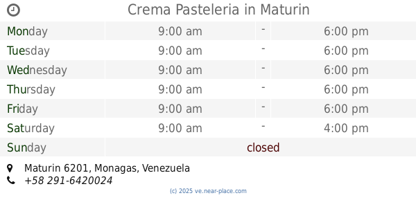
Maturín 6201, Monagas, Wenezuela
contacts phone
:
+58
Latitude:
9.7220361
, Longitude:
-63.1971622
larger map & directions
read more
nearest Bakery
140 m
Fiorpan The Guaritos
Maturin
Bakery
read more
140 m
Fiorpan Los Guaritos
Maturín
Bakery
read more
515 m
La Perla
Maturin
Bakery
read more
570 m
Panadería Y Pizzería Rayan,c.a
Maturin
Bakery
read more
748 m
Panaderia El Pan Dulce
Av Universidad, Maturín
Bakery
read more
748 m
The Pan Dulce Bakery
Av Universidad, Maturín
Bakery
read more
767 m
Ant. Bolívar
Avenida Principal Guaritos IV, Maturín
Bakery
read more
870 m
PANADERIA GEORGE
Maturin
Bakery
read more
1.761 km
Panaderia good sweet
Maturin
Bakery
read more
2.202 km
Panadería Brimarier
Maturín
Bakery
read more
2.309 km
Panadería El Bacha
Avenida Libertador, Maturín
Bakery
read more
2.463 km
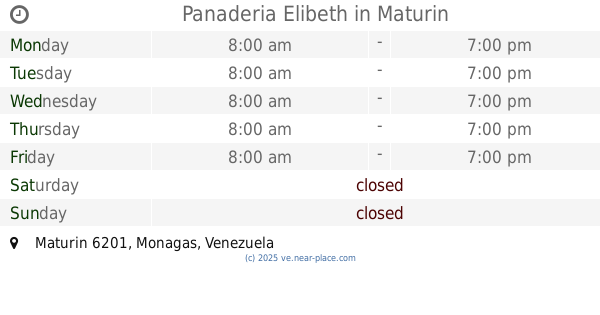
Panaderia Elibeth
Maturin
Bakery
read more
2.542 km
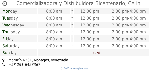
Comercializadora y Distribuidora Bicentenario, CA
Maturin
Bakery
read more
2.569 km
Gomets Distribucion C.A
Maturín
Bakery
read more
2.577 km
Panadería Y Pastelería Panichop
Calle Principal, Maturín
Bakery
read more
2.711 km
Panaderia y Pasteleria Fendy
Maturín
Bakery
read more
2.906 km
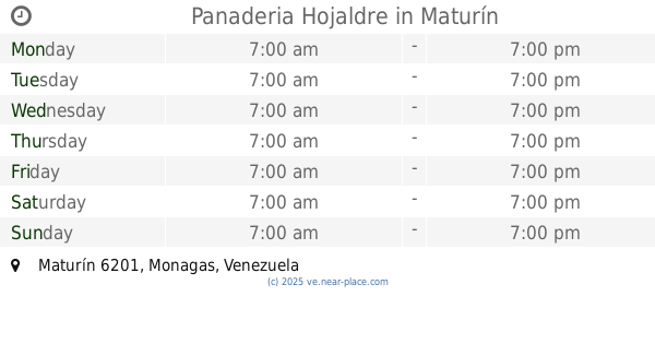
Panaderia Hojaldre
Maturín
Bakery
read more
3.154 km
Panaderia Mi Tierra de Oriente
Maturin
Bakery
read more
3.236 km
Panadería La Nonna I
Avenida Bicentenario, Maturín
Bakery
read more
3.379 km
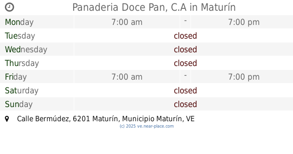
Panaderia Doce Pan, C.A
Calle Bermúdez, Maturín
Bakery
read more
3.493 km
Fiorpan
Calle Monagas, Maturín
Bakery
read more
3.573 km
Reposteria La Doña de Oriente
Calle El Centro, Maturín
Bakery
read more
3.715 km
Panaderia Adrimar
Avenida Luis del Valle García, Maturín
Bakery
read more
3.827 km
Valentina Piñateria y Confiteria
Maturin
Bakery
read more
3.829 km
Crema Pasteleria
Maturin
Bakery
read more
📑
all categories
Accounting
Administrative area level 1
Administrative area level 2
Airport
Amusement park
Aquarium
Art gallery
Atm
Bakery
Bank
Bar
Beauty salon
Bicycle store
Book store
Bowling alley
Bus station
Cafe
Campground
Car dealer
Car rental
Car repair
Car wash
Casino
Cemetery
Church
City hall
Clothing store
Colloquial area
Convenience store
Courthouse
Dentist
Department store
Doctor
Electrician
Electronics store
Embassy
Finance
Fire station
Florist
Food
Funeral home
Furniture store
Gas station
General contractor
Grocery or supermarket
Gym
Hair care
Hardware store
Health
Hindu Temple
Home goods store
Hospital
Insurance agency
Jewelry store
Laundry
Lawyer
Library
Light rail station
Liquor store
Local government office
Locality
Locksmith
Lodging
Meal delivery
Meal takeaway
Mosque
Movie rental
Movie theater
Moving company
Museum
Natural feature
Neighborhood
Night club
Painter
Park
Parking
Pet store
Pharmacy
Physiotherapist
Place of worship
Plumber
Point of interest
Police
Post office
Premise
Real estate agency
Restaurant
Roofing contractor
Route
Rv park, camping
School
Shoe store
Shopping mall
Spa
Stadium
Storage
Store
Subpremise
Subway station
Supermarket
Synagogue
Taxi stand
Train station
Transit station
Travel agency
University
Veterinary care
Zoo
administrative area level 3
sublocality level 1
↑