Bakery nearby Panaderia Los Luchos
Venezuela
Bakery nearby Panaderia Los Luchos
Panaderia Los Luchos
Maturin Venezuela, Bolivarische Republik
contacts phone
:
+58
Latitude:
9.6968716
, Longitude:
-63.2528313
read more
nearest Bakery
2.072 km
Panaderia y Pasteleria Mi Princesa Abreu
Calle 5, Maturín
Bakery
read more
2.795 km
Panadería Los Samanes
C.C. Los Samanes, Local Comercial, Maturín
Bakery
read more
5.088 km
Panaderia good sweet
Maturin
Bakery
read more
5.916 km
Gomets Distribucion C.A
Maturín
Bakery
read more
6.008 km
Panaderia El Pan Dulce
Av Universidad, Maturín
Bakery
read more
6.647 km
Panadería El Bacha
Avenida Libertador, Maturín
Bakery
read more
7.129 km
PANADERIA GEORGE
Maturin
Bakery
read more
9.377 km
Panaderia Mi Tierra de Oriente
Maturin
Bakery
read more
9.583 km
Panadería La Nonna I
Avenida Bicentenario, Maturín
Bakery
read more
9.694 km
Panaderia Maraisa II, C.A
Maturin
Bakery
read more
9.714 km
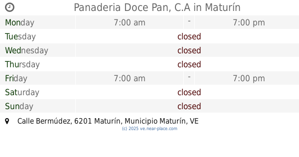
Panaderia Doce Pan, C.A
Calle Bermúdez, Maturín
Bakery
read more
9.721 km
Panaderia Petizes C.A
Centro,, Maturín
Bakery
read more
10.102 km
Reposteria La Doña de Oriente
Calle El Centro, Maturín
Bakery
read more
10.417 km
Valentina Piñateria y Confiteria
Maturin
Bakery
read more
10.62 km
Panaderia Entre Panes
Centro Comercial Cruz Mar, Maturín
Bakery
read more
10.682 km
Pastelería Monagas
Calle Villa Pool, Maturín
Bakery
read more
10.831 km
Chip-a-Cookie
Maturin
Bakery
read more
10.875 km
Polka Dots
Maturin
Bakery
read more
11.005 km
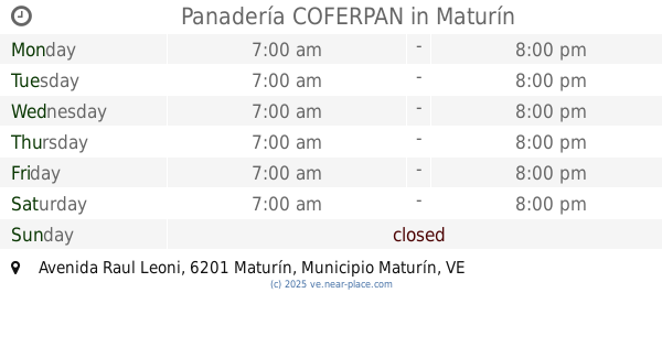
Panadería COFERPAN
Avenida Raul Leoni, Maturín
Bakery
read more
12 km
El Pan Redondo
Maturin
Bakery
read more
12.254 km
Cafedonia Café
Avenida Ugarte Pelayo, C, C. Monagas Plaza, Feria, Maturín
Bakery
read more
12.444 km
Panadería Yusmar
Maturin
Bakery
read more
12.642 km
Panaderia y charcuteria Orle
Maturin
Bakery
read more
12.775 km
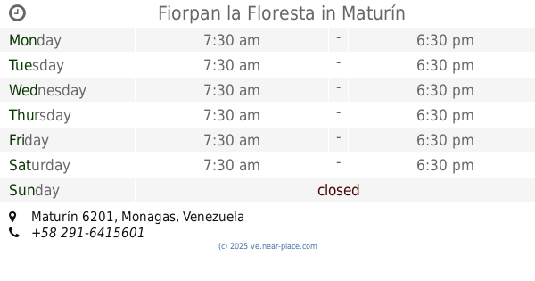
Fiorpan la Floresta
Maturín
Bakery
read more
14.919 km
Panaderia La Flor Del Araguaney CA
Maturin
Bakery
read more
📑
all categories
Accounting
Administrative area level 1
Administrative area level 2
Airport
Amusement park
Aquarium
Art gallery
Atm
Bakery
Bank
Bar
Beauty salon
Bicycle store
Book store
Bowling alley
Bus station
Cafe
Campground
Car dealer
Car rental
Car repair
Car wash
Casino
Cemetery
Church
City hall
Clothing store
Colloquial area
Convenience store
Courthouse
Dentist
Department store
Doctor
Electrician
Electronics store
Embassy
Finance
Fire station
Florist
Food
Funeral home
Furniture store
Gas station
General contractor
Grocery or supermarket
Gym
Hair care
Hardware store
Health
Hindu Temple
Home goods store
Hospital
Insurance agency
Jewelry store
Laundry
Lawyer
Library
Light rail station
Liquor store
Local government office
Locality
Locksmith
Lodging
Meal delivery
Meal takeaway
Mosque
Movie rental
Movie theater
Moving company
Museum
Natural feature
Neighborhood
Night club
Painter
Park
Parking
Pet store
Pharmacy
Physiotherapist
Place of worship
Plumber
Point of interest
Police
Post office
Premise
Real estate agency
Restaurant
Roofing contractor
Route
Rv park, camping
School
Shoe store
Shopping mall
Spa
Stadium
Storage
Store
Subpremise
Subway station
Supermarket
Synagogue
Taxi stand
Train station
Transit station
Travel agency
University
Veterinary care
Zoo
administrative area level 3
sublocality level 1
↑