Bar nearby Bar La Guayana
Venezuela
Bar nearby Bar La Guayana
Bar La Guayana
Calle 3, 5001, San Cristóbal, San Cristóbal, VE Venezuela
contacts phone
:
+58
Latitude:
7.7803908
, Longitude:
-72.2270983
larger map & directions
read more
nearest Bar
550 m
Clover Pub Bar
calle layola con calle cevitella local #c-21 sector la Guayana, San Cristóbal
Bar
read more
596 m
Bodega Mi Bodeguita
1 Avenida Ferrero Tamayo, San Cristóbal
Bar
read more
671 m
Bar La Perla de las Americas
San Cristóbal
Bar
read more
773 m
Peter's Bar
San Cristobal
Bar
read more
777 m
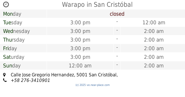
Warapo
Calle Jose Gregorio Hernandez, San Cristóbal
Bar
read more
836 m
El Bar De Otilia
11-6 Carrera 18, San Cristóbal
Bar
read more
906 m
Bar Restaurant La Sierra
San Cristóbal
Bar
read more
990 m
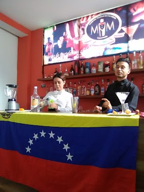
Academia Nacional De Cocteleria MM
San Cristóbal
Bar
read more
1.036 km
Licoreria Apricot c.a
Carrera 20, San Cristóbal
Bar
read more
1.049 km
Karaoke
Calle 14, San Cristóbal
Bar
read more
1.095 km
Aradi Bar & Bistro
Calle 14 entre Carreras 20 y 21, San Cristóbal
Bar
read more
1.096 km
Licorería El Paraiso
Calle 15, San Cristóbal
Bar
read more
1.125 km
Blue Room
San Cristobal
Bar
read more
1.127 km
Pietro's Bar
San Cristóbal
Bar
read more
1.197 km
Sargento Pimienta
San Cristobal
Bar
read more
1.249 km
LICORERIA LOS TOROROS
San Cristóbal
Bar
read more
1.356 km
Maria Bonita Lounge Bar
San Cristobal
Bar
read more
1.384 km
SC Beer Company
San Cristobal
Bar
read more
1.434 km
Bar Gay El Manuel's C.A
San Cristobal
Bar
read more
1.556 km
Stuggart_cafe
San Cristóbal
Bar
read more
1.61 km
Gabys Bar
San Cristóbal
Bar
read more
1.634 km
El Motobar
San Cristóbal
Bar
read more
1.645 km
Full House Food & Bar
San Cristobal
Bar
read more
1.855 km
Club La Gioconda
San Cristóbal
Bar
read more
2.043 km
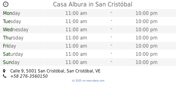
Casa Albura
Nº 52-52 y 25-68, Calle 9, San Cristóbal
Bar
read more
📑
all categories
Accounting
Administrative area level 1
Administrative area level 2
Airport
Amusement park
Aquarium
Art gallery
Atm
Bakery
Bank
Bar
Beauty salon
Bicycle store
Book store
Bowling alley
Bus station
Cafe
Campground
Car dealer
Car rental
Car repair
Car wash
Casino
Cemetery
Church
City hall
Clothing store
Colloquial area
Convenience store
Courthouse
Dentist
Department store
Doctor
Electrician
Electronics store
Embassy
Finance
Fire station
Florist
Food
Funeral home
Furniture store
Gas station
General contractor
Grocery or supermarket
Gym
Hair care
Hardware store
Health
Hindu Temple
Home goods store
Hospital
Insurance agency
Jewelry store
Laundry
Lawyer
Library
Light rail station
Liquor store
Local government office
Locality
Locksmith
Lodging
Meal delivery
Meal takeaway
Mosque
Movie rental
Movie theater
Moving company
Museum
Natural feature
Neighborhood
Night club
Painter
Park
Parking
Pet store
Pharmacy
Physiotherapist
Place of worship
Plumber
Point of interest
Police
Post office
Premise
Real estate agency
Restaurant
Roofing contractor
Route
Rv park, camping
School
Shoe store
Shopping mall
Spa
Stadium
Storage
Store
Subpremise
Subway station
Supermarket
Synagogue
Taxi stand
Train station
Transit station
Travel agency
University
Veterinary care
Zoo
administrative area level 3
sublocality level 1
↑