Bar nearby Los Faroles
Venezuela
Bar nearby Los Faroles
Los Faroles
Carrera 9, San Cristóbal Venezuela, Bolivarian Republic of
contacts phone
:
+58
Latitude:
7.7653015
, Longitude:
-72.2308156
read more
nearest Bar
535 m
Bar Tricolor
San Cristobal
Bar
read more
561 m
Tasca Caracas vieja
San Cristóbal
Bar
read more
715 m
Lalo's Pub&Bar
Calle 11, San Cristóbal
Bar
read more
831 m
Bar Restaurant La Sierra
San Cristóbal
Bar
read more
852 m
LICORERIA LOS TOROROS
San Cristóbal
Bar
read more
932 m
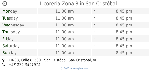
Licoreria Zona 8
10-38 Calle 8, San Cristóbal
Bar
read more
1.029 km
Tasca Ñañañaña - Pirineos1
Calle 5, San Cristóbal
Bar
read more
1.116 km
Bar La Perla de las Americas
San Cristóbal
Bar
read more
1.224 km
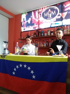
Academia Nacional De Cocteleria MM
San Cristóbal
Bar
read more
1.291 km
Blue Room
San Cristobal
Bar
read more
1.327 km
Bar Restaurant Sonorama
Calle 6 carrera 4 local 3-52 frente a plaza Venezuela, San Cristóbal
Bar
read more
1.376 km
Aradi Bar & Bistro
Calle 14 entre Carreras 20 y 21, San Cristóbal
Bar
read more
1.385 km
Gabys Bar
San Cristóbal
Bar
read more
1.427 km
El Motobar
San Cristóbal
Bar
read more
1.436 km
SC Beer Company
San Cristobal
Bar
read more
1.438 km
Pietro's Bar
San Cristóbal
Bar
read more
1.444 km
Stuggart_cafe
San Cristóbal
Bar
read more
1.495 km
Zona Fría C.A
San Cristobal
Bar
read more
1.548 km
Beer Box C.A
Avenida las flores, calle araguaney local 3-49, San Cristóbal
Bar
read more
1.661 km
Full House Food & Bar
San Cristobal
Bar
read more
1.711 km
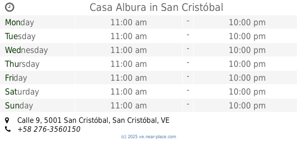
Casa Albura
Nº 52-52 y 25-68, Calle 9, San Cristóbal
Bar
read more
1.748 km
Bar Zulimar
San Cristobal
Bar
read more
1.777 km
Los Laguneros
San Cristobal
Bar
read more
1.851 km
Bodega Mi Bodeguita
1 Avenida Ferrero Tamayo, San Cristóbal
Bar
read more
2.165 km
Club La Gioconda
San Cristóbal
Bar
read more
📑
all categories
Accounting
Administrative area level 1
Administrative area level 2
Airport
Amusement park
Aquarium
Art gallery
Atm
Bakery
Bank
Bar
Beauty salon
Bicycle store
Book store
Bowling alley
Bus station
Cafe
Campground
Car dealer
Car rental
Car repair
Car wash
Casino
Cemetery
Church
City hall
Clothing store
Colloquial area
Convenience store
Courthouse
Dentist
Department store
Doctor
Electrician
Electronics store
Embassy
Finance
Fire station
Florist
Food
Funeral home
Furniture store
Gas station
General contractor
Grocery or supermarket
Gym
Hair care
Hardware store
Health
Hindu Temple
Home goods store
Hospital
Insurance agency
Jewelry store
Laundry
Lawyer
Library
Light rail station
Liquor store
Local government office
Locality
Locksmith
Lodging
Meal delivery
Meal takeaway
Mosque
Movie rental
Movie theater
Moving company
Museum
Natural feature
Neighborhood
Night club
Painter
Park
Parking
Pet store
Pharmacy
Physiotherapist
Place of worship
Plumber
Point of interest
Police
Post office
Premise
Real estate agency
Restaurant
Roofing contractor
Route
Rv park, camping
School
Shoe store
Shopping mall
Spa
Stadium
Storage
Store
Subpremise
Subway station
Supermarket
Synagogue
Taxi stand
Train station
Transit station
Travel agency
University
Veterinary care
Zoo
administrative area level 3
sublocality level 1
↑