Doctor nearby Radio Salud c.a
Venezuela
Doctor nearby Radio Salud c.a
Radio Salud c.a
Calle 128, Valencia Venezuela, República Bolivariana de
contacts phone
:
+58
Latitude:
10.2029596
, Longitude:
-68.008897
read more
nearest Doctor
112 m
Centro de Especialidades Caribbean (Odontología)
Valencia
Doctor
read more
137 m
Consultorio De Celular Madres, Salud Y Estética
Calle 128, Valencia
Doctor
read more
275 m
Clinica de rehabilitacion valencia
Calle 130 Prebo, Valencia
Doctor
read more
287 m
AMP Consultorio Valencia
Valencia
Doctor
read more
297 m
SILCA Salud Integral Laboral
Valencia 2001
Doctor
read more
414 m
Centro De Especialidades Médicas "Santa Lucía"
Valencia
Doctor
read more
460 m
Instituto Medico Integral
Calle 131, Valencia
Doctor
read more
521 m
Centro Médico Multisalud
Calle 131, Valencia
Doctor
read more
521 m
Multisalud Medical Center
Calle 131, Valencia
Doctor
read more
570 m
Emergencia Medica Integral EMI centro, c.a.
Valencia
Doctor
read more
619 m
Instituto Clinico Camoruco
Valencia
Doctor
read more
632 m
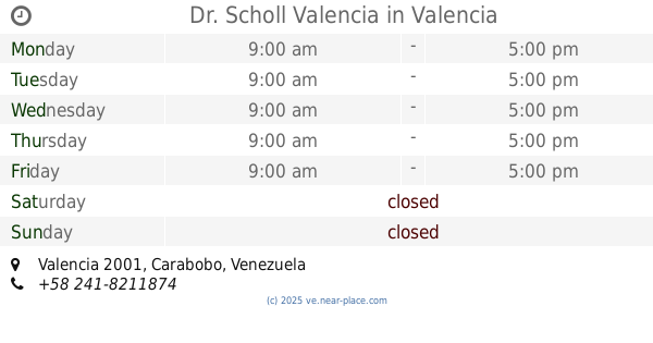
Dr. Scholl Valencia
Valencia
Doctor
read more
673 m
seguros universitas
Avenida Andres Eloy Blanco (Servicio), Valencia
Doctor
read more
689 m
Súper Óptica Gar-mar
Calle 137, Valencia
Doctor
read more
729 m
Umoval
Valencia
Doctor
read more
736 m
Audifon
Venezuela, Valencia
Doctor
read more
766 m
CENTRO DE DIAGNOSTICO DEL PIE
cc shopping center local 395, Avenida Andres Eloy Blanco (Servicio), Valencia
Doctor
read more
909 m
Centro Médico PREBO. Consulta de Cirugía Plástica
2001, Valencia
Doctor
read more
910 m
Funcamama
Calle Las Delicias, Valencia
Doctor
read more
920 m
Consultorio de Endocrinología
Valencia
Doctor
read more
928 m
Laboratorio Bioanalítico El Viñedo
Valencia
Doctor
read more
1.026 km
Althea Fisioterapia Total
Paseo Cuatricentenario, Valencia
Doctor
read more
1.066 km
Clinica Dr. Ronquillo
Valencia
Doctor
read more
1.071 km
Clinica Ronquillo
Valencia
Doctor
read more
1.17 km
Centro Odontologico de Estetica e Implantes
2001, Valencia
Doctor
read more
📑
all categories
Accounting
Administrative area level 1
Administrative area level 2
Airport
Amusement park
Aquarium
Art gallery
Atm
Bakery
Bank
Bar
Beauty salon
Bicycle store
Book store
Bowling alley
Bus station
Cafe
Campground
Car dealer
Car rental
Car repair
Car wash
Casino
Cemetery
Church
City hall
Clothing store
Colloquial area
Convenience store
Courthouse
Dentist
Department store
Doctor
Electrician
Electronics store
Embassy
Finance
Fire station
Florist
Food
Funeral home
Furniture store
Gas station
General contractor
Grocery or supermarket
Gym
Hair care
Hardware store
Health
Hindu Temple
Home goods store
Hospital
Insurance agency
Jewelry store
Laundry
Lawyer
Library
Light rail station
Liquor store
Local government office
Locality
Locksmith
Lodging
Meal delivery
Meal takeaway
Mosque
Movie rental
Movie theater
Moving company
Museum
Natural feature
Neighborhood
Night club
Painter
Park
Parking
Pet store
Pharmacy
Physiotherapist
Place of worship
Plumber
Point of interest
Police
Post office
Premise
Real estate agency
Restaurant
Roofing contractor
Route
Rv park, camping
School
Shoe store
Shopping mall
Spa
Stadium
Storage
Store
Subpremise
Subway station
Supermarket
Synagogue
Taxi stand
Train station
Transit station
Travel agency
University
Veterinary care
Zoo
administrative area level 3
sublocality level 1
↑