Local government office nearby santa rosalia 警务站
Venezuela
Local government office nearby santa rosalia 警务站
santa rosalia 警务站
Caracas 1041, Hauptstadtdistrikt, Venezuela
contacts phone
:
+58
Latitude:
10.4794311
, Longitude:
-66.901049
larger map & directions
read more
nearest Local government office
308 m
Registro Civil El Paraiso
Capital District
Local government office
read more
308 m
Registro Civil El Paraiso
Distrito Capital
Local government office
read more
356 m
San Pedro Prefecture
Calle Los Malabares, Caracas
Local government office
read more
356 m
Prefectura san pedro
Calle Los Malabares, Caracas
Local government office
read more
1.033 km
Registro Civil de Santa Rosalía
Avenida Ayacucho, Caracas
Local government office
read more
1.191 km
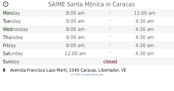
SAIME Santa Mónica
Edif. Centauro, Avenida Francisco Lazo Martí, Caracas
Local government office
read more
1.27 km
Instituto de Oncologia y Hematologia
Caracas
Local government office
read more
1.299 km
Parish Civil Registration Unit El Valle
Caracas
Local government office
read more
1.299 km
Unidad Parroquial de Registro Civil El Valle
Caracas
Local government office
read more
1.468 km
Cuerpo De Policia Nacional Bolivariana
Caracas,
Local government office
read more
1.747 km
Inhrr
Ciudad Universitaria, Caracas
Local government office
read more
1.799 km
Registro Civil San Agustín
Caracas
Local government office
read more
2.133 km
Land Traffic Command
Comandancia Sector Centro, Puente Hierro, Avenida Sur 5, Caracas
Local government office
read more
2.148 km
Ministerio Del Poder Popular De Planificación
Caracas
Local government office
read more
2.38 km
el regalo universal, c.a.
Avenida Las Acacias, Caracas
Local government office
read more
2.569 km
Municipal Institute of Sport and Recreation
Avenida Casanova, Caracas
Local government office
read more
2.569 km
Instituto Municipal de Deporte y Recreación
Avenida Casanova, Caracas
Local government office
read more
2.574 km
oficina regional cne
Paseo Colón, Caracas
Local government office
read more
2.684 km
Alcaldía de Caracas
Avenida Lima, Caracas
Local government office
read more
2.731 km
Consejo Federal de Gobierno
Caracas
Local government office
read more
2.933 km
National Institute for Prevention, Health and Safety
Avenida Este 0, Caracas
Local government office
read more
2.956 km
Sede del Ministerio Público
Principal de La Candelaria, Caracas
Local government office
read more
3.05 km
Ministerio de Alimentación
Edificio Las Fundaciones, Avenida Andrés Bello, Caracas
Local government office
read more
3.176 km
MPPS
Avenida Bolívar, Caracas
Local government office
read more
3.272 km
Juuzgado 25 del Municipio
Edificio Tepuy, Avenida Francisco Solano Lopez, Caracas
Local government office
read more
📑
all categories
Accounting
Administrative area level 1
Administrative area level 2
Airport
Amusement park
Aquarium
Art gallery
Atm
Bakery
Bank
Bar
Beauty salon
Bicycle store
Book store
Bowling alley
Bus station
Cafe
Campground
Car dealer
Car rental
Car repair
Car wash
Casino
Cemetery
Church
City hall
Clothing store
Colloquial area
Convenience store
Courthouse
Dentist
Department store
Doctor
Electrician
Electronics store
Embassy
Finance
Fire station
Florist
Food
Funeral home
Furniture store
Gas station
General contractor
Grocery or supermarket
Gym
Hair care
Hardware store
Health
Hindu Temple
Home goods store
Hospital
Insurance agency
Jewelry store
Laundry
Lawyer
Library
Light rail station
Liquor store
Local government office
Locality
Locksmith
Lodging
Meal delivery
Meal takeaway
Mosque
Movie rental
Movie theater
Moving company
Museum
Natural feature
Neighborhood
Night club
Painter
Park
Parking
Pet store
Pharmacy
Physiotherapist
Place of worship
Plumber
Point of interest
Police
Post office
Premise
Real estate agency
Restaurant
Roofing contractor
Route
Rv park, camping
School
Shoe store
Shopping mall
Spa
Stadium
Storage
Store
Subpremise
Subway station
Supermarket
Synagogue
Taxi stand
Train station
Transit station
Travel agency
University
Veterinary care
Zoo
administrative area level 3
sublocality level 1
↑