Lodging nearby Hotel Villa Jardín
Venezuela
Lodging nearby Hotel Villa Jardín
Hotel Villa Jardín
Avenida San Martín, Barinas Venezuela, Bolivarian Republic of
contacts phone
:
+58
Latitude:
8.6175656
, Longitude:
-70.2042548
read more
nearest Lodging
593 m
Hotel Amaruco
Barinas
Lodging
read more
680 m
Hotel Villa Los Angeles
Barinas
Lodging
read more
1.08 km
Urb La Concordia
Calle Merida, Barinas
Lodging
read more
1.306 km
Hotel Oriente
Barinas
Lodging
read more
1.349 km
Hotel Barroco
Barinas
Lodging
read more
1.704 km
Hotel Carrizal Suites
Avenida Sucre, Barinas
Lodging
read more
1.738 km
Hotel Victoria
Barinas
Lodging
read more
1.76 km
Hostal Canaima Suites
c/, Intersección Avenida 23 de enero con Calle Mérida, Barinas
Lodging
read more
1.775 km
Hotel Comercio
Venezuela
Lodging
read more
1.907 km
El Marqués
Calle Bolivar, Barinas
Lodging
read more
2.025 km
Hotel Bristol
Avenida 23 de Enero, Barinas
Lodging
read more
2.057 km
Edificio Montevago
Avenida Montilla, Barinas
Lodging
read more
2.103 km
Hotel MONACO
Barinas
Lodging
read more
2.118 km
Hotel Estrella Del Paraíso
Barinas
Lodging
read more
2.122 km
Hotel La Estrella Del Paraiso
Calle 12, Barinas
Lodging
read more
2.203 km
Virgen Del Valle
Barinas
Lodging
read more
2.243 km
Hotel Villa Real
Avenida Escobar, Barinas
Lodging
read more
2.258 km
Edificio El Trigal
Calle Camejo, Barinas
Lodging
read more
2.322 km
RESIDENCIAS VILLA REAL
Avenida San Luis, Barinas
Lodging
read more
2.452 km
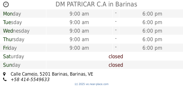
DM PATRICAR C.A
Calle Camejo, Barinas
Lodging
read more
2.463 km
Hotel Turístico Varyna
Barinas
Lodging
read more
2.621 km
Hotel Fantacia
Barinas
Lodging
read more
3.01 km
Posada La Estancia Barinas
Barinas
Lodging
read more
3.456 km
Posada el Toreño
Avenida San Silvestre, Barinas
Lodging
read more
3.469 km
Hotel Alto Llano c.a
Barinas
Lodging
read more
📑
all categories
Accounting
Administrative area level 1
Administrative area level 2
Airport
Amusement park
Aquarium
Art gallery
Atm
Bakery
Bank
Bar
Beauty salon
Bicycle store
Book store
Bowling alley
Bus station
Cafe
Campground
Car dealer
Car rental
Car repair
Car wash
Casino
Cemetery
Church
City hall
Clothing store
Colloquial area
Convenience store
Courthouse
Dentist
Department store
Doctor
Electrician
Electronics store
Embassy
Finance
Fire station
Florist
Food
Funeral home
Furniture store
Gas station
General contractor
Grocery or supermarket
Gym
Hair care
Hardware store
Health
Hindu Temple
Home goods store
Hospital
Insurance agency
Jewelry store
Laundry
Lawyer
Library
Light rail station
Liquor store
Local government office
Locality
Locksmith
Lodging
Meal delivery
Meal takeaway
Mosque
Movie rental
Movie theater
Moving company
Museum
Natural feature
Neighborhood
Night club
Painter
Park
Parking
Pet store
Pharmacy
Physiotherapist
Place of worship
Plumber
Point of interest
Police
Post office
Premise
Real estate agency
Restaurant
Roofing contractor
Route
Rv park, camping
School
Shoe store
Shopping mall
Spa
Stadium
Storage
Store
Subpremise
Subway station
Supermarket
Synagogue
Taxi stand
Train station
Transit station
Travel agency
University
Veterinary care
Zoo
administrative area level 3
sublocality level 1
↑