Night club nearby Mantras Disco Music Club
Venezuela
Night club nearby Mantras Disco Music Club
Mantras Disco Music Club
San Cristóbal Venezuela, República Bolivariana de
contacts phone
:
+58
Latitude:
7.7859662
, Longitude:
-72.2342759
read more
nearest Night club
88 m
CHAMPION SPORT BOOK C.A.
San Cristóbal
Night club
read more
1.223 km
Night Club Gioconda
San Cristóbal
Night club
read more
1.288 km
Bar La Gioconda
Calle Mirador, San Antonio de Los Altos
Night club
read more
1.388 km
El Vainazo
Avenida Las Lomas, San Cristóbal
Night club
read more
1.929 km
Iglesia De Testigos De Cato
Carrera 17, San Cristóbal
Night club
read more
1.961 km
Aradi Bar
San Cristóbal
Night club
read more
2.028 km
Karaoke How-Yen
San Cristobal
Night club
read more
2.1 km
The View bar & Lounge
San Cristóbal
Night club
read more
2.143 km
Vapiano lounge Bar
San Cristobal
Night club
read more
2.236 km
Cantinero Bistro Bar
Carrera 19, San Cristóbal
Night club
read more
2.422 km
Monedita De Oro
San Cristobal
Night club
read more
2.459 km
U2 Rock Café
Pasaje Acueducto, San Cristóbal
Night club
read more
2.47 km
Beisbil Tabaco Y Ron
Pasaje Acueducto, San Cristóbal
Night club
read more
2.47 km
Beisbol Tabaco Y Ron
Pasaje Acueducto, San Cristóbal
Night club
read more
2.496 km
Salon de Festejos D´Etiqueta
San Cristobal
Night club
read more
2.496 km
Discoteca Bla Bla
Carrera 22, San Cristóbal
Night club
read more
2.539 km
BODEGON LA GUACARA
San Cristóbal
Night club
read more
2.571 km
Smoka
Calle 11, San Cristóbal
Night club
read more
2.743 km
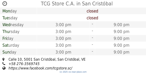
TCG Store C.A.
Calle 10, San Cristóbal
Night club
read more
2.801 km
San Cristóbal Tennis Club
Avenida 19 de Abril, San Cristóbal
Night club
read more
3.351 km
Rancho Club Las Orquideas
San Cristobal
Night club
read more
3.493 km
Alambike Café
Asogata, Avenida Universidad, San Cristóbal
Night club
read more
4.095 km
Grupo Dimension
Tariba
Night club
read more
4.374 km
Club Rancho Gaby
Calle La Morenita, Táriba
Night club
read more
4.424 km
Club El Sendero
San Cristóbal
Night club
read more
📑
all categories
Accounting
Administrative area level 1
Administrative area level 2
Airport
Amusement park
Aquarium
Art gallery
Atm
Bakery
Bank
Bar
Beauty salon
Bicycle store
Book store
Bowling alley
Bus station
Cafe
Campground
Car dealer
Car rental
Car repair
Car wash
Casino
Cemetery
Church
City hall
Clothing store
Colloquial area
Convenience store
Courthouse
Dentist
Department store
Doctor
Electrician
Electronics store
Embassy
Finance
Fire station
Florist
Food
Funeral home
Furniture store
Gas station
General contractor
Grocery or supermarket
Gym
Hair care
Hardware store
Health
Hindu Temple
Home goods store
Hospital
Insurance agency
Jewelry store
Laundry
Lawyer
Library
Light rail station
Liquor store
Local government office
Locality
Locksmith
Lodging
Meal delivery
Meal takeaway
Mosque
Movie rental
Movie theater
Moving company
Museum
Natural feature
Neighborhood
Night club
Painter
Park
Parking
Pet store
Pharmacy
Physiotherapist
Place of worship
Plumber
Point of interest
Police
Post office
Premise
Real estate agency
Restaurant
Roofing contractor
Route
Rv park, camping
School
Shoe store
Shopping mall
Spa
Stadium
Storage
Store
Subpremise
Subway station
Supermarket
Synagogue
Taxi stand
Train station
Transit station
Travel agency
University
Veterinary care
Zoo
administrative area level 3
sublocality level 1
↑