Park nearby Plaza Francisco de Miranda
Venezuela
Park nearby Plaza Francisco de Miranda
Plaza Francisco de Miranda
Avenida Baralt, 1010, Caracas, Libertador, VE Venezuela
contacts phone
:
+58
Latitude:
10.5019787
, Longitude:
-66.9186638
larger map & directions
read more
nearest Park
164 m
Parque Urbano
Caracas
Park
read more
193 m
Plaza Caracas
Avenida Bolívar, Caracas Metropolitan District
Park
read more
368 m
Plaza Ali Primera
Caracas
Park
read more
397 m
Plaza El Parnaso
Caracas,
Park
read more
438 m
Plaza La Concordia
Avenida Sur 2, Caracas
Park
read more
504 m
Sala de Lectura Paula Correa
1030, La Planicie, Caracas
Park
read more
523 m
Arco de la Federación
Capital District
Park
read more
546 m
El Calvario
La Planicie, Caracas
Park
read more
556 m
esequiel zamora Park
Avenida El Estanque, Caracas
Park
read more
556 m
parque esequiel zamora
Avenida El Estanque, Caracas
Park
read more
695 m
Parque Miraflores
Centro
Park
read more
713 m
Plaza El Venezolano
Avenida Sur 1, Caracas
Park
read more
1.015 km
Parque Infantil Manuelita Sáenz
Quinta Crespo
Park
read more
1.044 km
Plaza 4F
Caracas
Park
read more
1.382 km
Parque José María Vargas
Caracas
Park
read more
1.398 km
Plaza Madariaga
Avenida José Antonio Páez, Caracas
Park
read more
1.4 km
Plaza La Pastora
Avenida Norte 10, Caracas
Park
read more
1.416 km
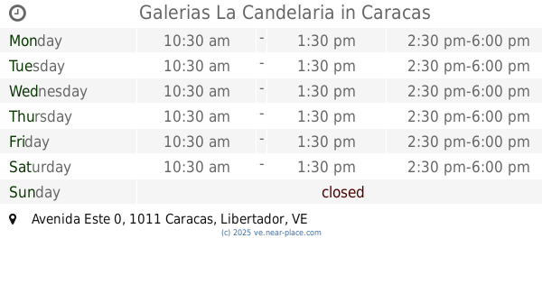
Galerias La Candelaria
Avenida Este 0, Caracas
Park
read more
1.461 km
Parque Tajamar
Avenida Norte 14, Caracas
Park
read more
1.461 km
Tajamar Park
Avenida Norte 14, Caracas
Park
read more
1.516 km
Plaza Parque Carabobo
Caracas
Park
read more
2.057 km
Plaza Anauco
San Bernardino
Park
read more
2.304 km
Plaza La Montaña
Caracas
Park
read more
2.37 km
Gato Negro
Caracas
Park
read more
2.725 km
Alí Primera Park
Avenida Sucre, Caracas
Park
read more
📑
all categories
Accounting
Administrative area level 1
Administrative area level 2
Airport
Amusement park
Aquarium
Art gallery
Atm
Bakery
Bank
Bar
Beauty salon
Bicycle store
Book store
Bowling alley
Bus station
Cafe
Campground
Car dealer
Car rental
Car repair
Car wash
Casino
Cemetery
Church
City hall
Clothing store
Colloquial area
Convenience store
Courthouse
Dentist
Department store
Doctor
Electrician
Electronics store
Embassy
Finance
Fire station
Florist
Food
Funeral home
Furniture store
Gas station
General contractor
Grocery or supermarket
Gym
Hair care
Hardware store
Health
Hindu Temple
Home goods store
Hospital
Insurance agency
Jewelry store
Laundry
Lawyer
Library
Light rail station
Liquor store
Local government office
Locality
Locksmith
Lodging
Meal delivery
Meal takeaway
Mosque
Movie rental
Movie theater
Moving company
Museum
Natural feature
Neighborhood
Night club
Painter
Park
Parking
Pet store
Pharmacy
Physiotherapist
Place of worship
Plumber
Point of interest
Police
Post office
Premise
Real estate agency
Restaurant
Roofing contractor
Route
Rv park, camping
School
Shoe store
Shopping mall
Spa
Stadium
Storage
Store
Subpremise
Subway station
Supermarket
Synagogue
Taxi stand
Train station
Transit station
Travel agency
University
Veterinary care
Zoo
administrative area level 3
sublocality level 1
↑