Restaurant nearby Caminos Pizza
Venezuela
Restaurant nearby Caminos Pizza
Caminos Pizza
Maracaibo Venezuela, Bolivarian Republic of
contacts phone
:
+58
Latitude:
10.6716223
, Longitude:
-71.6899629
read more
nearest Restaurant
18 m
pastelitos la fuerza
Carretera Vía La Concepción, Maracaibo
Restaurant
read more
370 m
Pizza - Maica
Maracaibo
Restaurant
read more
443 m
134lagunaburger
Maracaibo
Restaurant
read more
873 m
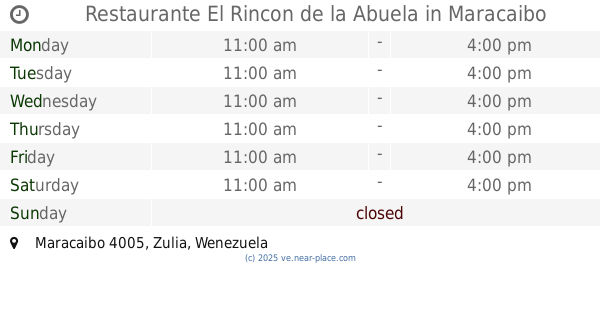
Restaurante El Rincon de la Abuela
Maracaibo
Restaurant
read more
1.033 km
EL PEZ CADITO DE ORO
Maracaibo
Restaurant
read more
1.109 km
Pastelitos Carrito
Maracaibo
Restaurant
read more
1.146 km
Pa Ke Chendo
Maracaibo
Restaurant
read more
1.179 km
Pastelillos los Dos Cujis
Maracaibo
Restaurant
read more
1.198 km
Richard Pizza
Maracaibo
Restaurant
read more
1.216 km
Tostada El Papi
Maracaibo
Restaurant
read more
1.219 km
peña hípica la fogata
Maracaibo
Restaurant
read more
1.238 km
Rospo Pizza
Avenida 82A, Maracaibo
Restaurant
read more
1.242 km
Desayunos El Hambre
Maracaibo
Restaurant
read more
1.252 km
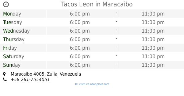
Tacos Leon
Maracaibo
Restaurant
read more
1.262 km
Restaurat El Gustazo
Carretera Vía La Concepción, Maracaibo
Restaurant
read more
1.345 km
Asadero Kai Kai
Avenida 84, Maracaibo
Restaurant
read more
1.376 km
El Sabor De Victoria
Avenida 84, Maracaibo
Restaurant
read more
1.528 km
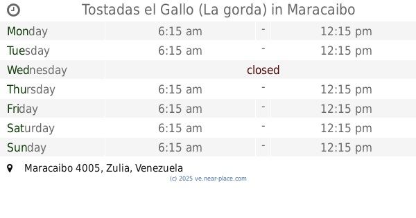
Tostadas el Gallo (La gorda)
Maracaibo
Restaurant
read more
1.54 km
Empanadas Evelini
Maracaibo
Restaurant
read more
1.615 km
Pizzeria Burda
Maracaibo
Restaurant
read more
1.703 km
Tostada pa que el gocho
Calle 1A-1, Maracaibo
Restaurant
read more
1.824 km
Tostada Zulia
Maracaibo
Restaurant
read more
1.944 km
Caribe Consert
Maracaibo
Restaurant
read more
2.403 km
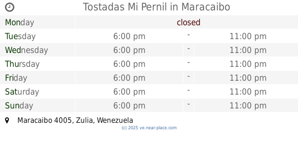
Tostadas Mi Pernil
Maracaibo
Restaurant
read more
2.495 km
Restaurante Pekin
Maracaibo
Restaurant
read more
📑
all categories
Accounting
Administrative area level 1
Administrative area level 2
Airport
Amusement park
Aquarium
Art gallery
Atm
Bakery
Bank
Bar
Beauty salon
Bicycle store
Book store
Bowling alley
Bus station
Cafe
Campground
Car dealer
Car rental
Car repair
Car wash
Casino
Cemetery
Church
City hall
Clothing store
Colloquial area
Convenience store
Courthouse
Dentist
Department store
Doctor
Electrician
Electronics store
Embassy
Finance
Fire station
Florist
Food
Funeral home
Furniture store
Gas station
General contractor
Grocery or supermarket
Gym
Hair care
Hardware store
Health
Hindu Temple
Home goods store
Hospital
Insurance agency
Jewelry store
Laundry
Lawyer
Library
Light rail station
Liquor store
Local government office
Locality
Locksmith
Lodging
Meal delivery
Meal takeaway
Mosque
Movie rental
Movie theater
Moving company
Museum
Natural feature
Neighborhood
Night club
Painter
Park
Parking
Pet store
Pharmacy
Physiotherapist
Place of worship
Plumber
Point of interest
Police
Post office
Premise
Real estate agency
Restaurant
Roofing contractor
Route
Rv park, camping
School
Shoe store
Shopping mall
Spa
Stadium
Storage
Store
Subpremise
Subway station
Supermarket
Synagogue
Taxi stand
Train station
Transit station
Travel agency
University
Veterinary care
Zoo
administrative area level 3
sublocality level 1
↑