Restaurant nearby Mavi
Venezuela
Restaurant nearby Mavi
Mavi
366, Calle San Francisco, San Juan Venezuela, Bolivarische Republik
contacts phone
:
+58
Latitude:
18.4662836
, Longitude:
-66.1126167
read more
nearest Restaurant
68 m
Aguaviva
364 Calle Fortaleza, San Juan
Restaurant
read more
72 m
Tantra
356 Calle Fortaleza, San Juan
Restaurant
read more
75 m
El Asador
350 Calle San Francisco, San Juan
Restaurant
read more
105 m
Marmalade
317 Calle Fortaleza, San Juan
Restaurant
read more
123 m
Bien Papayas
500 Calle Norzagaray, San Juan
Restaurant
read more
137 m
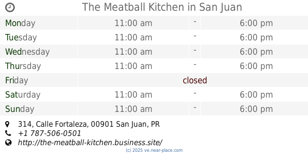
The Meatball Kitchen
314 Calle Fortaleza, San Juan
Restaurant
read more
158 m
Genesis
327 Calle Recinto Sur, San Juan
Restaurant
read more
185 m
Pirilo
207 Calle Tanca, San Juan
Restaurant
read more
240 m
Las Palmas
281 Calle San Sebastián, San Juan
Restaurant
read more
265 m
Restaurant Palmas
281 Calle San Sebastián, San Juan
Restaurant
read more
266 m
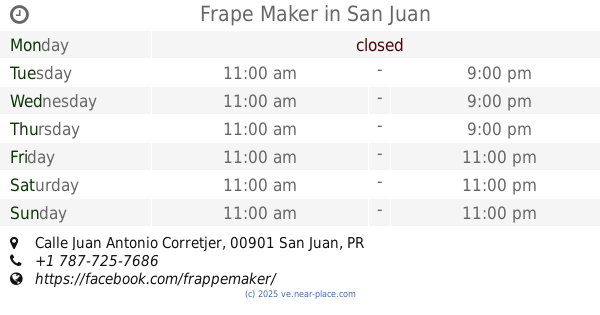
Frape Maker
Calle Juan Antonio Corretjer, San Juan
Restaurant
read more
302 m
La Mallorquina
207 Calle San Justo, San Juan
Restaurant
read more
331 m
Subway Restaurants
Old San Juan, Pier #2, San Juan
Restaurant
read more
347 m
A tu gusto
301 Calle San Justo, San Juan
Restaurant
read more
360 m
Senior's Hot Dog
Puerto Rico 1, San Juan
Restaurant
read more
581 m
El Parnaso
251 Calle del Cristo, San Juan
Restaurant
read more
601 m
Cafeina Tasca
Condominio Capitolio Plaza 00901
Restaurant
read more
641 m
Melao Bistro
Calle Marina, Cond. Capitolio Plaza Ste. 201, San Juan
Restaurant
read more
643 m
Ostra Cosa
San Juan
Restaurant
read more
648 m
La Pincho
Paseo de la Princesa, San Juan
Restaurant
read more
648 m
Ostra Cosa
Calle del Cristo, San Juan
Restaurant
read more
652 m
Capi Q Neighborhood Bar and Grill
100 Calle Marina, San Juan
Restaurant
read more
672 m
Bar Negroni
100 Calle Marina, San Juan
Restaurant
read more
706 m
Encayao
Calle Pershing, San Juan
Restaurant
read more
727 m
Lemongrass
San Juan
Restaurant
read more
📑
all categories
Accounting
Administrative area level 1
Administrative area level 2
Airport
Amusement park
Aquarium
Art gallery
Atm
Bakery
Bank
Bar
Beauty salon
Bicycle store
Book store
Bowling alley
Bus station
Cafe
Campground
Car dealer
Car rental
Car repair
Car wash
Casino
Cemetery
Church
City hall
Clothing store
Colloquial area
Convenience store
Courthouse
Dentist
Department store
Doctor
Electrician
Electronics store
Embassy
Finance
Fire station
Florist
Food
Funeral home
Furniture store
Gas station
General contractor
Grocery or supermarket
Gym
Hair care
Hardware store
Health
Hindu Temple
Home goods store
Hospital
Insurance agency
Jewelry store
Laundry
Lawyer
Library
Light rail station
Liquor store
Local government office
Locality
Locksmith
Lodging
Meal delivery
Meal takeaway
Mosque
Movie rental
Movie theater
Moving company
Museum
Natural feature
Neighborhood
Night club
Painter
Park
Parking
Pet store
Pharmacy
Physiotherapist
Place of worship
Plumber
Point of interest
Police
Post office
Premise
Real estate agency
Restaurant
Roofing contractor
Route
Rv park, camping
School
Shoe store
Shopping mall
Spa
Stadium
Storage
Store
Subpremise
Subway station
Supermarket
Synagogue
Taxi stand
Train station
Transit station
Travel agency
University
Veterinary care
Zoo
administrative area level 3
sublocality level 1
↑