School nearby calle los apamate
Venezuela
School nearby calle los apamate
calle los apamate
Calle Los Apamates, 4148, Judibana, Los Taques, VE Venezuela
contacts phone
:
+58 426-1222738
Latitude:
11.760849
, Longitude:
-70.187914
larger map & directions
read more
nearest School
378 m
Escuela Básica Judibana
Calle 15, Judibana
School
read more
378 m
Basic school Judibana
Calle 15, Judibana
School
read more
469 m
Liceo Nacional Judibana
Judibana
School
read more
558 m
U.E. Colegio Francisco de Miranda
11°45'26. 70°11'03., Troncal 5
School
read more
635 m
U.E.Francisco de Miranda
Calle 6, Judibana
School
read more
1.119 km
Instituto Judibana
Judibana
School
read more
1.162 km
Instituto Educativo Judibana
Judibana
School
read more
1.401 km
Escuela Simón Bolívar
Judibana
School
read more
1.444 km
UEA Simón Bolívar
Judibana
School
read more
1.93 km
Escuela Basica Guanadito
Guanadito
School
read more
1.952 km
Escuela Primaria Nacional Guanadito
11°46'36. 70°10'49., 4
School
read more
2.365 km
Liceo Nacional Hugo Rafael Chávez Frías - Los Taques
4, Barquisimeto
School
read more
2.763 km
Centro de Educación Inicial Divina Pastora
11°44'18. 70°10'36., 6 6
School
read more
2.763 km
Centro de Educación Inicial Divina Pastora
11°44'18. 70°10'36., 6 Troncal6
School
read more
3.168 km
Escuela Básica Rómulo Betancourt
Via Fluor, Punto Fijo
School
read more
3.259 km
Escuela Primaria Nacional Don Simón Rodríguez
Coranime C.A., 11°44'17. 70°10'08., 1 Autopista José Antonio Páez, Tinaquillo
School
read more
3.397 km
Centro de Educación Inicial El Cardonal
11°44'12.0"N 70°10'07., 8
School
read more
3.658 km
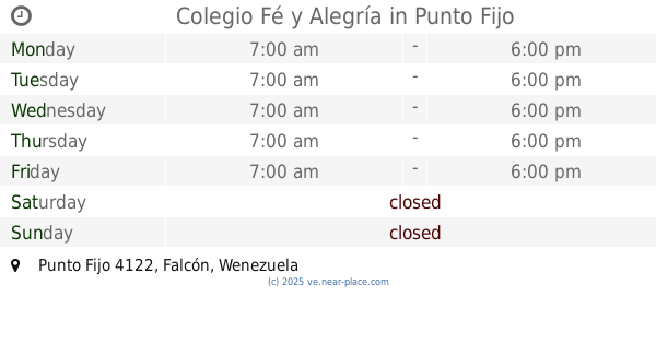
Colegio Fé y Alegría
Punto Fijo
School
read more
3.677 km
U.E. COlegio Sagrada Familia
Punto Fijo
School
read more
3.749 km
Centro de Educación Inicial Simoncito 4 de Febrero
11°44'02. 70°10'01., 6
School
read more
4.248 km
Colegio Madre Cecilia Sector La Chinita
Punto Fijo
School
read more
4.605 km
Centro de Educacion Inicial ANTIGUO AEROPUERTO
Punto Fijo
School
read more
4.611 km
Escuela Básica Antiguo Aeropuerto
Punto Fijo
School
read more
4.924 km
Dr. Carlos Diez Basic Liceo Deer
Punto Fijo
School
read more
4.982 km
Instituto Educativo Paraguaná
Calle Libertador, Punto Fijo
School
read more
📑
all categories
Accounting
Administrative area level 1
Administrative area level 2
Airport
Amusement park
Aquarium
Art gallery
Atm
Bakery
Bank
Bar
Beauty salon
Bicycle store
Book store
Bowling alley
Bus station
Cafe
Campground
Car dealer
Car rental
Car repair
Car wash
Casino
Cemetery
Church
City hall
Clothing store
Colloquial area
Convenience store
Courthouse
Dentist
Department store
Doctor
Electrician
Electronics store
Embassy
Finance
Fire station
Florist
Food
Funeral home
Furniture store
Gas station
General contractor
Grocery or supermarket
Gym
Hair care
Hardware store
Health
Hindu Temple
Home goods store
Hospital
Insurance agency
Jewelry store
Laundry
Lawyer
Library
Light rail station
Liquor store
Local government office
Locality
Locksmith
Lodging
Meal delivery
Meal takeaway
Mosque
Movie rental
Movie theater
Moving company
Museum
Natural feature
Neighborhood
Night club
Painter
Park
Parking
Pet store
Pharmacy
Physiotherapist
Place of worship
Plumber
Point of interest
Police
Post office
Premise
Real estate agency
Restaurant
Roofing contractor
Route
Rv park, camping
School
Shoe store
Shopping mall
Spa
Stadium
Storage
Store
Subpremise
Subway station
Supermarket
Synagogue
Taxi stand
Train station
Transit station
Travel agency
University
Veterinary care
Zoo
administrative area level 3
sublocality level 1
↑