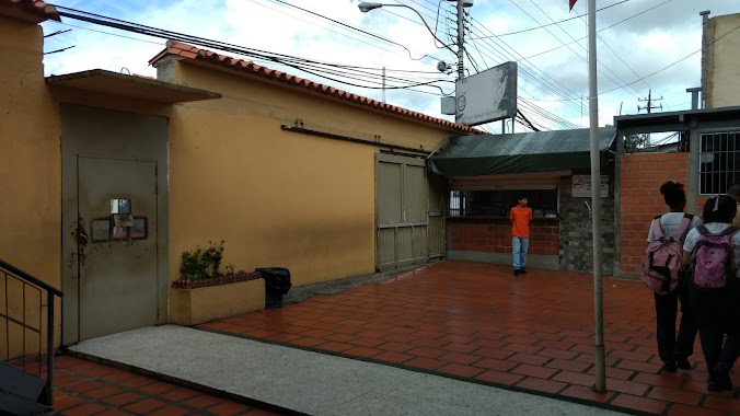
School nearby Escuela Manuel Piar
Venezuela
School nearby Escuela Manuel Piar
Escuela Manuel Piar
Maturín Venezuela, República Bolivariana de
contacts phone
:
+58
Latitude:
9.7410327
, Longitude:
-63.1936813
read more
nearest School
16 m
Manuel Piar
Maturín
School
read more
22 m
E.B. "Manuel Piar"
Maturín
School
read more
212 m
U. E. I. "Nuevos Horizontes"
Maturín
School
read more
212 m
U. E. I. "New Horizons"
Maturin
School
read more
228 m
brisas de orinoco
Avenida Orinoco, Maturín
School
read more
346 m
Liceo Francisco Isnardi.U.E.F.I”
Avenida Bolivar, Maturín
School
read more
346 m
Liceo Francisco Isnardi
Avenida Bolivar, Maturín
School
read more
353 m
Liceo Bolivariano Ildefonso Nuñez Mares
San Simón
School
read more
443 m
Unidad Educativa De Formacion Integral Luisa Caceres De Arismendi en Maturin Monagas
Calle 29, Maturín
School
read more
447 m
UNEFI LUISA CÁCERES DE ARISMENDI
7, Calle 29, Maturín
School
read more
506 m
Escuela Basica Boyacá
Maturín
School
read more
610 m
Oasis De Bendicion SC
Maturin
School
read more
616 m
U. E OASIS DE BENDICION
Maturín
School
read more
651 m
Unidad Educativa Colegio Adventista Dr. Braulio Pérez Marcio
Maturin
School
read more
744 m
U.E.Isabel La Católica
Urb. Alberto Ravel, Maturín
School
read more
746 m
Prescolar Libertador
Urbanización Alberto Ravel, Maturín
School
read more
756 m
E.B.B. Felix Antonio Calderon
Maturin
School
read more
847 m
Unefi Luisa Caceres De Arismendi
Maturín
School
read more
885 m
Alejandro De Humboldt
Maturin
School
read more
885 m
Escuela Publica Estadal Felix Angel Lozada
Maturin
School
read more
959 m
ALLEGRO Escuela de Piano
Maturín
School
read more
1.013 km
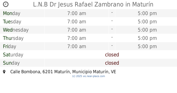
L.N.B Dr Jesus Rafael Zambrano
Calle Bombona, Maturín
School
read more
1.132 km
C.E.I "Rosa Adela De Hernández
Calle 30-B, Maturín
School
read more
1.155 km
Preescolar Alto de Los Godos I
Maturin
School
read more
1.297 km
U.E."Rosa Adela de Hernández"
Maturín
School
read more
📑
all categories
Accounting
Administrative area level 1
Administrative area level 2
Airport
Amusement park
Aquarium
Art gallery
Atm
Bakery
Bank
Bar
Beauty salon
Bicycle store
Book store
Bowling alley
Bus station
Cafe
Campground
Car dealer
Car rental
Car repair
Car wash
Casino
Cemetery
Church
City hall
Clothing store
Colloquial area
Convenience store
Courthouse
Dentist
Department store
Doctor
Electrician
Electronics store
Embassy
Finance
Fire station
Florist
Food
Funeral home
Furniture store
Gas station
General contractor
Grocery or supermarket
Gym
Hair care
Hardware store
Health
Hindu Temple
Home goods store
Hospital
Insurance agency
Jewelry store
Laundry
Lawyer
Library
Light rail station
Liquor store
Local government office
Locality
Locksmith
Lodging
Meal delivery
Meal takeaway
Mosque
Movie rental
Movie theater
Moving company
Museum
Natural feature
Neighborhood
Night club
Painter
Park
Parking
Pet store
Pharmacy
Physiotherapist
Place of worship
Plumber
Point of interest
Police
Post office
Premise
Real estate agency
Restaurant
Roofing contractor
Route
Rv park, camping
School
Shoe store
Shopping mall
Spa
Stadium
Storage
Store
Subpremise
Subway station
Supermarket
Synagogue
Taxi stand
Train station
Transit station
Travel agency
University
Veterinary care
Zoo
administrative area level 3
sublocality level 1
↑