School nearby U. E. Colegio El Carmelo
Venezuela
School nearby U. E. Colegio El Carmelo
U. E. Colegio El Carmelo
Avenida Pichincha, 1040, Caracas, Libertador, VE Venezuela
contacts phone
:
+58 212-6330601
website:
www.colegioelcarmelo.com
Latitude:
10.4871156
, Longitude:
-66.8986702
larger map & directions
read more
nearest School
229 m
CENDA
Avenida Presidente Medina, Caracas
School
read more
340 m
Pedro Victor
Avenida La Colina, Caracas
School
read more
401 m
Colegio Las Acacias
Avenida El Parque, Caracas
School
read more
454 m
Colegio Padre Machado Fe y Alegría
Caracas
School
read more
486 m
HTEI
Caracas
School
read more
514 m
Faculta de Mediciana - UCV
Caracas
School
read more
564 m
Unidad Educativa Colegio Nuestra Madre
Calle Nicaragua, Quinta Rayo, Avenida Nicaragua, Caracas
School
read more
662 m
Escuela de Acupuntura Nei-Jing
Caracas
School
read more
672 m
ucv quimica
Avenida Caroni, Caracas
School
read more
684 m
E.S.Salias
Avenida El Parque, Caracas
School
read more
698 m
U.E.N. Humberto Parodi Alister
Avenida El Cortijo, Caracas
School
read more
752 m
Náutico Lino de Clemente
Caracas
School
read more
764 m
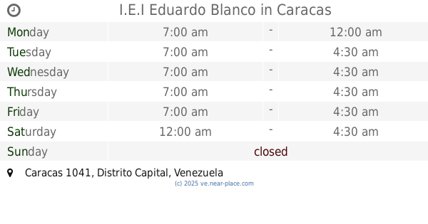
I.E.I Eduardo Blanco
Caracas
School
read more
787 m
Colegio Fe y Alegría Don Pedro
Caracas
School
read more
811 m
U.E.N.B. DR. NICOLAS MENDIBLE
Av El Paseo,, Caracas
School
read more
844 m
Colegio San Pedro
Avenida Ciudad Universitaria, Caracas
School
read more
904 m
U.E.Psicopedagoguico.La Paz
Caracas
School
read more
904 m
Nuevo Horizonte
Caracas
School
read more
904 m
Anbv
Caracas
School
read more
936 m
Colegio Juan XXIII
Caracas
School
read more
1.06 km
YVERDON
Calle 2, Caracas
School
read more
1.226 km
Colegio Los Chaguaramos
Caracas
School
read more
1.245 km
U.E. Colegio Santa Elvira
Caracas, Calle Teresa Carreño, Quinta Lala, Urbanización Santa Mónica,
School
read more
1.256 km
Preescolar Negra Hipolita
Santa Mónica,Caracas 1041
School
read more
1.258 km
Santa Caterina Da Siena
Quinta Coromoto, Calle Agustin Codazzi, Caracas
School
read more
📑
all categories
Accounting
Administrative area level 1
Administrative area level 2
Airport
Amusement park
Aquarium
Art gallery
Atm
Bakery
Bank
Bar
Beauty salon
Bicycle store
Book store
Bowling alley
Bus station
Cafe
Campground
Car dealer
Car rental
Car repair
Car wash
Casino
Cemetery
Church
City hall
Clothing store
Colloquial area
Convenience store
Courthouse
Dentist
Department store
Doctor
Electrician
Electronics store
Embassy
Finance
Fire station
Florist
Food
Funeral home
Furniture store
Gas station
General contractor
Grocery or supermarket
Gym
Hair care
Hardware store
Health
Hindu Temple
Home goods store
Hospital
Insurance agency
Jewelry store
Laundry
Lawyer
Library
Light rail station
Liquor store
Local government office
Locality
Locksmith
Lodging
Meal delivery
Meal takeaway
Mosque
Movie rental
Movie theater
Moving company
Museum
Natural feature
Neighborhood
Night club
Painter
Park
Parking
Pet store
Pharmacy
Physiotherapist
Place of worship
Plumber
Point of interest
Police
Post office
Premise
Real estate agency
Restaurant
Roofing contractor
Route
Rv park, camping
School
Shoe store
Shopping mall
Spa
Stadium
Storage
Store
Subpremise
Subway station
Supermarket
Synagogue
Taxi stand
Train station
Transit station
Travel agency
University
Veterinary care
Zoo
administrative area level 3
sublocality level 1
↑