School nearby U.E. Dr. Raul Leoni
Venezuela
School nearby U.E. Dr. Raul Leoni
U.E. Dr. Raul Leoni
El Tigre Venezuela, Bolivarian Republic of
contacts phone
:
+58
Latitude:
8.8929964
, Longitude:
-64.253665
read more
nearest School
16 m
Escuela Raul Leonis
El Tigre
School
read more
151 m
U.E.P ``Moral y Luces´´
El Tigre
School
read more
474 m
CEI JUAN JOSE RONDON
Carrera 10 Norte, El Tigre
School
read more
482 m
U.E.P "Moral Y Luces"
quinta carrera norte entre 5ta y, 6ta Calle Norte, El Tigre
School
read more
492 m
Colegio Fermín Toro
3era Carrera Norte, El Tigre
School
read more
549 m
Du Louvre Academia de Artes
8°53'49.0"N 64°15'02., Avenida 4, El Tigre
School
read more
576 m
U.E.P "Luis Manuel Urbaneja Achelpohl"
El Tigre
School
read more
649 m
unidad educativa churum meru
Avenida Peñalver, El Tigre
School
read more
710 m
Guardería Pasitos de Ángel
El Tigre
School
read more
720 m
U.E. Diego Bautista Urbaneja
El Tigre
School
read more
723 m
Colegio San Antonio de Padua
4ta Carrera Sur, El Tigre
School
read more
733 m
Escuela Diego Bautista Urbaneja
El Tigre
School
read more
764 m
Taller Libre de Arte El Tigre
Calle Táchira, El Tigre
School
read more
796 m
INCES
4ta Carrera Sur, El Tigre
School
read more
808 m
Preescolar Francisca Duarte
El Tigre
School
read more
827 m
Escuela Básica Simón Rodríguez
3era Carrera Norte, El Tigre
School
read more
1.011 km
Escuela básica Santelíz Peña
Parroquia Miguel Otero Silva
School
read more
1.014 km
UEN Santeliz Peña
El Tigre
School
read more
1.017 km
Escuela basica Jose Mercedes Santeliz Peña
El Tigre
School
read more
1.02 km
Escuela Básica Santeliz Peña
El Tigre
School
read more
1.19 km
Escuela Básica Estado Trujillo
El Tigre
School
read more
1.238 km
Liceo Briceño Mendez
Avenida Peñalver, El Tigre
School
read more
1.25 km
U.E.P Nuestra Señora Del Pilar
El Tigre
School
read more
1.549 km
Escuela La Esperanza
El Tigre
School
read more
2.547 km
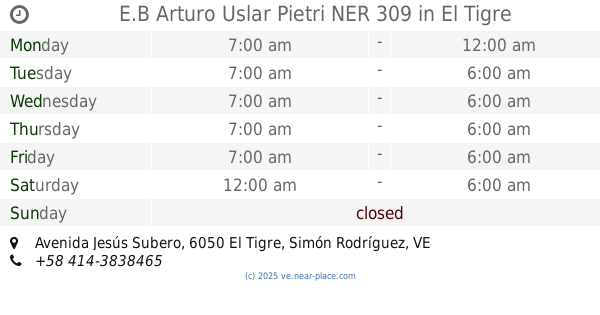
E.B Arturo Uslar Pietri NER 309
Avenida Jesús Subero, El Tigre
School
read more
📑
all categories
Accounting
Administrative area level 1
Administrative area level 2
Airport
Amusement park
Aquarium
Art gallery
Atm
Bakery
Bank
Bar
Beauty salon
Bicycle store
Book store
Bowling alley
Bus station
Cafe
Campground
Car dealer
Car rental
Car repair
Car wash
Casino
Cemetery
Church
City hall
Clothing store
Colloquial area
Convenience store
Courthouse
Dentist
Department store
Doctor
Electrician
Electronics store
Embassy
Finance
Fire station
Florist
Food
Funeral home
Furniture store
Gas station
General contractor
Grocery or supermarket
Gym
Hair care
Hardware store
Health
Hindu Temple
Home goods store
Hospital
Insurance agency
Jewelry store
Laundry
Lawyer
Library
Light rail station
Liquor store
Local government office
Locality
Locksmith
Lodging
Meal delivery
Meal takeaway
Mosque
Movie rental
Movie theater
Moving company
Museum
Natural feature
Neighborhood
Night club
Painter
Park
Parking
Pet store
Pharmacy
Physiotherapist
Place of worship
Plumber
Point of interest
Police
Post office
Premise
Real estate agency
Restaurant
Roofing contractor
Route
Rv park, camping
School
Shoe store
Shopping mall
Spa
Stadium
Storage
Store
Subpremise
Subway station
Supermarket
Synagogue
Taxi stand
Train station
Transit station
Travel agency
University
Veterinary care
Zoo
administrative area level 3
sublocality level 1
↑