Subway station nearby MetroCable San Agustín
Venezuela
Subway station nearby MetroCable San Agustín
MetroCable San Agustín
Avenida Leonardo Ruíz Pineda, 1014, Caracas, Libertador, VE Venezuela
contacts phone
:
+58
Latitude:
10.4941026
, Longitude:
-66.9101014
larger map & directions
read more
nearest Subway station
690 m
Nuevo Circo
Avenida Lecuna, Caracas
Subway station
read more
1.026 km
Parque Carabobo
México prolongación Avenida, Avenida Universidad, Caracas
Subway station
read more
1.038 km
La Hoyada
Avenida Sur 5, Caracas
Subway station
read more
1.113 km
Teatros
Avenida Lecuna, Caracas
Subway station
read more
1.246 km
Metro Parque Central
Caracas
Subway station
read more
1.302 km
Bellas Artes
Avenida México, Caracas
Subway station
read more
1.476 km
Capitolio
esquina de carmelitas, Caracas
Subway station
read more
1.48 km
El Silencio
Avenida Sur 8, Caracas
Subway station
read more
1.748 km
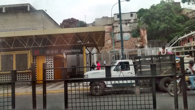
Capuchinos (L2)
Avenida San Martín, Caracas
Subway station
read more
1.787 km
Capuchinos
Venezuela
Subway station
read more
1.955 km
La Bandera
Avenida Nueva Granada, Caracas
Subway station
read more
1.965 km
Los Símbolos
Avenida Paseo Los Ilustres, Caracas
Subway station
read more
2.088 km
Colegio de Ingenieros
Calle Caroni, Caracas
Subway station
read more
2.175 km
Caño Amarillo
Calle Los Jabillos, Caracas
Subway station
read more
2.385 km
Ciudad Universitaria
Venezuela
Subway station
read more
2.528 km
Maternidad
Avenida San Martín, Caracas
Subway station
read more
2.884 km
El Valle
Estación del metro El Valle
Subway station
read more
2.965 km
Zona Rental (L4)
Caracas
Subway station
read more
3.112 km
Agua Salud
Avenida Sucre, Caracas
Subway station
read more
3.168 km
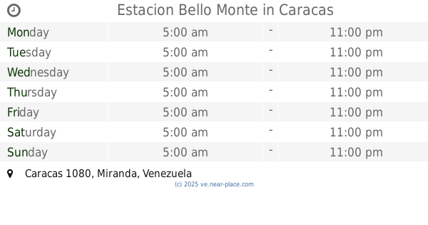
Estacion del metro bello monte
Colinas de Santa Mónica, Caracas
Subway station
read more
3.941 km
Los Jardines (L3)
Avenida Intercomunal del Valle, Caracas
Subway station
read more
3.969 km
Estacion Bello Monte
Caracas
Subway station
read more
4.035 km
Gato Negro (L1)
Avenida Sucre, Caracas
Subway station
read more
4.035 km
Gato Negro
Avenida Sucre, Caracas
Subway station
read more
5.096 km
Propatria
2da Avenida, Caracas
Subway station
read more
📑
all categories
Accounting
Administrative area level 1
Administrative area level 2
Airport
Amusement park
Aquarium
Art gallery
Atm
Bakery
Bank
Bar
Beauty salon
Bicycle store
Book store
Bowling alley
Bus station
Cafe
Campground
Car dealer
Car rental
Car repair
Car wash
Casino
Cemetery
Church
City hall
Clothing store
Colloquial area
Convenience store
Courthouse
Dentist
Department store
Doctor
Electrician
Electronics store
Embassy
Finance
Fire station
Florist
Food
Funeral home
Furniture store
Gas station
General contractor
Grocery or supermarket
Gym
Hair care
Hardware store
Health
Hindu Temple
Home goods store
Hospital
Insurance agency
Jewelry store
Laundry
Lawyer
Library
Light rail station
Liquor store
Local government office
Locality
Locksmith
Lodging
Meal delivery
Meal takeaway
Mosque
Movie rental
Movie theater
Moving company
Museum
Natural feature
Neighborhood
Night club
Painter
Park
Parking
Pet store
Pharmacy
Physiotherapist
Place of worship
Plumber
Point of interest
Police
Post office
Premise
Real estate agency
Restaurant
Roofing contractor
Route
Rv park, camping
School
Shoe store
Shopping mall
Spa
Stadium
Storage
Store
Subpremise
Subway station
Supermarket
Synagogue
Taxi stand
Train station
Transit station
Travel agency
University
Veterinary care
Zoo
administrative area level 3
sublocality level 1
↑