School nearby Pasillo De Las Banderas
Venezuela
School nearby Pasillo De Las Banderas
Pasillo De Las Banderas
Unnamed Road, Caracas 1053 Venezuela, Bolivarian Republic of
contacts phone
:
+58
Latitude:
10.4911897
, Longitude:
-66.8914661
read more
nearest School
231 m
Escuela de Geografía
Caracas
School
read more
312 m
Escuela de Geografia UCV
Caracas
School
read more
398 m
Faculta de Mediciana - UCV
Caracas
School
read more
470 m
Galpones UCV Bioanálisis
Caracas
School
read more
538 m
Escuela de Bioanálisis
1053,, Caracas
School
read more
557 m
Ucv Facultad de idiomas
Calle Interna UCV, Caracas
School
read more
571 m
Centro de Excursionismo Universitario
Caracas
School
read more
673 m
Liceo Leopoldo Aguerrevere
Calle Codazzi, Caracas
School
read more
714 m
Colegio San Pedro
Avenida Ciudad Universitaria, Caracas
School
read more
795 m
Escuela de Acupuntura Nei-Jing
Caracas
School
read more
814 m
ucv quimica
Avenida Caroni, Caracas
School
read more
816 m
Pedro Victor
Avenida La Colina, Caracas
School
read more
864 m
El Ateneo Popular De Los Chaguaramos
Unnamed Road, Caracas 1041
School
read more
909 m
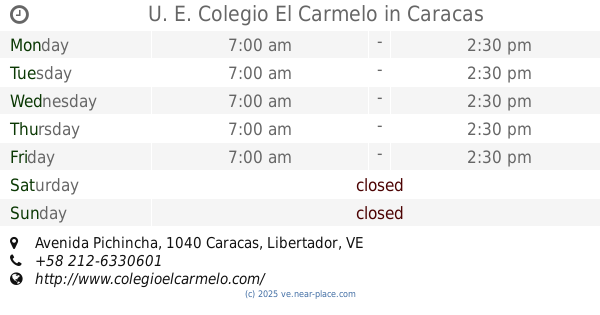
U. E. Colegio El Carmelo
Avenida Pichincha, Caracas
School
read more
930 m
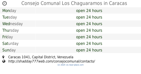
Consejo Comunal Los Chaguaramos
Caracas
School
read more
963 m
Escuela Audio Caracas
Calle Los Chaguaramos, Caracas
School
read more
970 m
HTEI
Caracas
School
read more
971 m
Postgrado UCV Los Chaguaramos
26 Avenida Neveri, Caracas
School
read more
976 m
Distrito Escolar Numero 1
Calle Zuloaga, Caracas
School
read more
995 m
Grupo Scout Neptuno Distrito Avila Asociacion de scouts de Venezuela
San Agustín,Caracas
School
read more
1.019 km
Grupo Leibniz
Av. Lima, Torre Phelps, Piso 10, Oficina 10D, Plaza Venezuela, Venezuela
School
read more
1.036 km
AsoVAC
Edf Fundavac,, Avenida Neveri, Caracas
School
read more
1.052 km
CENDA
Avenida Presidente Medina, Caracas
School
read more
1.135 km
INPREABOGADO
Avenida La Salle, Caracas
School
read more
1.293 km
College Seven Stars
Avenida Bogotá, Caracas
School
read more
📑
all categories
Accounting
Administrative area level 1
Administrative area level 2
Airport
Amusement park
Aquarium
Art gallery
Atm
Bakery
Bank
Bar
Beauty salon
Bicycle store
Book store
Bowling alley
Bus station
Cafe
Campground
Car dealer
Car rental
Car repair
Car wash
Casino
Cemetery
Church
City hall
Clothing store
Colloquial area
Convenience store
Courthouse
Dentist
Department store
Doctor
Electrician
Electronics store
Embassy
Finance
Fire station
Florist
Food
Funeral home
Furniture store
Gas station
General contractor
Grocery or supermarket
Gym
Hair care
Hardware store
Health
Hindu Temple
Home goods store
Hospital
Insurance agency
Jewelry store
Laundry
Lawyer
Library
Light rail station
Liquor store
Local government office
Locality
Locksmith
Lodging
Meal delivery
Meal takeaway
Mosque
Movie rental
Movie theater
Moving company
Museum
Natural feature
Neighborhood
Night club
Painter
Park
Parking
Pet store
Pharmacy
Physiotherapist
Place of worship
Plumber
Point of interest
Police
Post office
Premise
Real estate agency
Restaurant
Roofing contractor
Route
Rv park, camping
School
Shoe store
Shopping mall
Spa
Stadium
Storage
Store
Subpremise
Subway station
Supermarket
Synagogue
Taxi stand
Train station
Transit station
Travel agency
University
Veterinary care
Zoo
administrative area level 3
sublocality level 1
↑